
Original file (1,102 × 1,259 pixels, file size: 590 KB, MIME type: image/jpeg)
Summary
edit
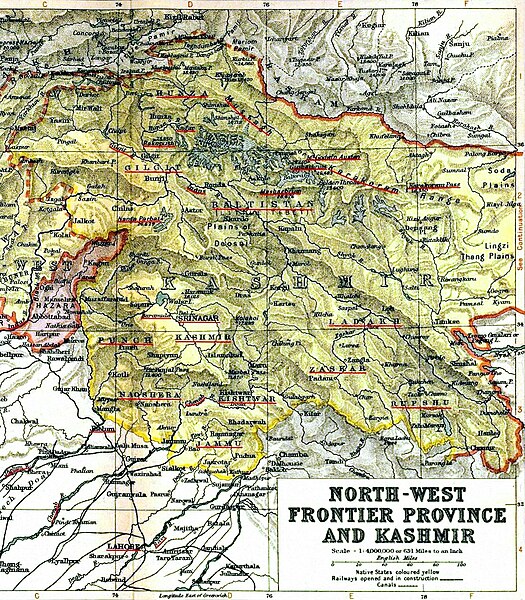
This is the image of the map "North West Frontier Province and Kashmir" from the Imperial Gazetteer of India, 1909, Oxford University Press, which was scanned from a personal copy and then annotated (with the regions, rivers, and mountains underlined in red) by Fowler&fowler«Talk» 21:02, 27 March 2007 (UTC)
Licensing
edit
| This file is in the public domain in countries with a copyright term of life of the author plus 70 years or less. |  | |||
| ||||
 | This file is a candidate to be copied to Wikimedia Commons.
Any user may perform this transfer; refer to Wikipedia:Moving files to Commons for details. If this file has problems with attribution, copyright, or is otherwise ineligible for Commons, then remove this tag and DO NOT transfer it; repeat violators may be blocked from editing. Other Instructions
| ||
| |||
File history
Click on a date/time to view the file as it appeared at that time.
| Date/Time | Thumbnail | Dimensions | User | Comment | |
|---|---|---|---|---|---|
| current | 16:18, 6 June 2010 | | 1,102 × 1,259 (590 KB) | MegA (talk | contribs) | improved contrast and legibility, removed yellowing |
| 15:37, 6 June 2010 |  | 1,102 × 1,259 (462 KB) | Beao (talk | contribs) | ||
| 22:05, 27 March 2007 |  | 1,110 × 1,296 (457 KB) | Fowler&fowler (talk | contribs) | This is the image of the map "North West Frontier Province and Kashmir" from the Imperial Gazetteer of India, 1909, Oxford University Press, which was scanned from a personal copy and then annotated (with the regions, rivers, and mountains underlined in r | |
| 21:20, 27 March 2007 |  | 730 × 870 (212 KB) | Fowler&fowler (talk | contribs) | This is the image of the map "North West Frontier Province and Kashmir" from the Imperial Gazetteer of India, 1909, Oxford University Press, which was scanned from a personal copy and then cropped (to only show the Kashmir region) and annotated (with the | |
| 21:02, 27 March 2007 |  | 1,133 × 892 (322 KB) | Fowler&fowler (talk | contribs) | This is the image of the map "North West Frontier Province and Kashmir" from the Imperial Gazetteer of India, 1909, Oxford University Press, which was scanned from a personal copy and then annotated (with the regions shown within red rectangles) by ~~~~ { |
You cannot overwrite this file.