File:Permian Flaring 2012-2016.jpg

Original file (626 × 678 pixels, file size: 256 KB, MIME type: image/jpeg)

Summary

Description
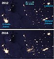
English: The night time view of the earth was made possible by the "day-night band" of the Visible Infrared Imaging Radiometer Suite. VIIRS detects light in a range of wavelengths from green to near-infrared and uses filtering techniques to observe dim signals such as gas flares, auroras, wildfires, city lights, and reflected moonlight. In this case, auroras, fires, and other stray light have been removed. The 2012 and 2016 data is processed so that researchers can compare and contrast light sources over the years. (Description based on information provided by NASA Eath Observatory)
Date
Source Derived from https://earthobservatory.nasa.gov/features/NightLights/page3.php
Author NASA and NASA's Earth Observatory - Suomi National Polar-orbiting Partnership (Suomi NPP) Satellite provided the VIIRS imagery. Labels added by bikesrcool.

View of west Texas and southeast New Mexico in the United States.

Licensing

Public domain This file is in the public domain in the United States because it was solely created by NASA. NASA copyright policy states that "NASA material is not protected by copyright unless noted". (See Template:PD-USGov, NASA copyright policy page or JPL Image Use Policy.)
Warnings:
Annotations
InfoField
This image is annotated: View the annotations at Commons

Captions

Growith in gas flaring from oil wells in the U.S. Permian Basin as viewed from space; 2012-2016.

Items portrayed in this file

depicts

File history

Click on a date/time to view the file as it appeared at that time.

Date/TimeThumbnailDimensionsUserComment
current18:15, 4 January 2020Thumbnail for version as of 18:15, 4 January 2020626 × 678 (256 KB)BikesrcoolUser created page with UploadWizard

The following page uses this file: