Size of this preview: 528 × 600 pixels. Other resolutions: 211 × 240 pixels | 602 × 684 pixels.
Original file (602 × 684 pixels, file size: 71 KB, MIME type: image/jpeg)
| This is a file from the Wikimedia Commons. Information from its description page there is shown below. Commons is a freely licensed media file repository. You can help. |
Summary
| Description |
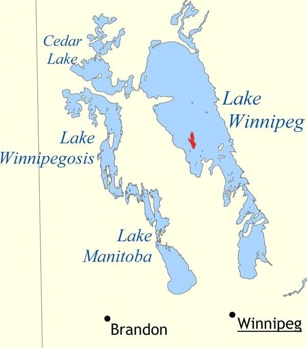
English: Map highlighting the location of Reindeer Island, in Lake Winnipeg, Manitoba, Canada.
Français : Carte de localisation de l'île Reindeer, dans le lac Winnipeg, état de Manitoba au Canada.
|
| Date | |
| Source | Own work |
| Author | Miyagawa |
Licensing
I, the copyright holder of this work, hereby publish it under the following license:
This file is licensed under the Creative Commons Attribution-Share Alike 3.0 Unported license.
- You are free:
- to share – to copy, distribute and transmit the work
- to remix – to adapt the work
- Under the following conditions:
- attribution – You must give appropriate credit, provide a link to the license, and indicate if changes were made. You may do so in any reasonable manner, but not in any way that suggests the licensor endorses you or your use.
- share alike – If you remix, transform, or build upon the material, you must distribute your contributions under the same or compatible license as the original.
File history
Click on a date/time to view the file as it appeared at that time.
| Date/Time | Thumbnail | Dimensions | User | Comment | |
|---|---|---|---|---|---|
| current | 21:29, 13 December 2009 | | 602 × 684 (71 KB) | Miyagawa | Cropped Saskatchewan out of the image - it was making the map a bit confusing. |
| 21:26, 13 December 2009 |  | 640 × 684 (76 KB) | Miyagawa | Cropped and brightened. | |
| 21:24, 13 December 2009 |  | 925 × 894 (131 KB) | Miyagawa | {{Information |Description={{en|1=Map highlighting the location of Reindeer Lake.}} |Source={{own}} |Author=Miyagawa |Date=2009-12-13 |Permission= |other_versions= }} Category:Maps of Manitoba |
File usage
The following pages on the English Wikipedia use this file (pages on other projects are not listed):
Global file usage
The following other wikis use this file:
- Usage on ceb.wikipedia.org
- Usage on es.wikipedia.org
- Usage on fi.wikipedia.org
- Usage on ja.wikipedia.org
- Usage on sv.wikipedia.org
- Usage on uk.wikipedia.org
- Usage on www.wikidata.org