No higher resolution available.
Rio_1555_França_Antártica.jpg (500 × 500 pixels, file size: 58 KB, MIME type: image/jpeg)
| This is a file from the Wikimedia Commons. Information from its description page there is shown below. Commons is a freely licensed media file repository. You can help. |
Summary
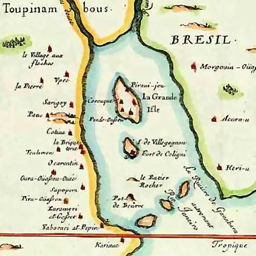
Mapa francês da baía de Guanabara em 1555, por Duval.
French map of Guanabara Bay in 1555, by Duval.
Copyleft. See http://serqueira.com.br/mapas/frances.htm
Licensing
|
This work is in the public domain in its country of origin and other countries and areas where the copyright term is the author's life plus 70 years or fewer. | |
| This file has been identified as being free of known restrictions under copyright law, including all related and neighboring rights. | |
File history
Click on a date/time to view the file as it appeared at that time.
| Date/Time | Thumbnail | Dimensions | User | Comment | |
|---|---|---|---|---|---|
| current | 22:24, 20 January 2006 | | 500 × 500 (58 KB) | Mschlindwein | Mapa da Baía da Guanabara em 1555 Guanabara Bay in 1555 Copyleft |
File usage
The following pages on the English Wikipedia use this file (pages on other projects are not listed):
Global file usage
The following other wikis use this file:
- Usage on af.wikipedia.org
- Usage on ar.wikipedia.org
- Usage on br.wikipedia.org
- Usage on bs.wikipedia.org
- Usage on ca.wikipedia.org
- Usage on cs.wikipedia.org
- Usage on da.wikipedia.org
- Usage on de.wikipedia.org
- Usage on eo.wikipedia.org
- Usage on es.wikipedia.org
- Usage on fr.wikipedia.org
- 1555
- Henri II (roi de France)
- Rio de Janeiro
- Rouge Brésil
- Liste des colonies françaises
- Nicolas Durand de Villegagnon
- Histoire du Brésil
- France antarctique
- Fort Coligny
- Yves d'Évreux
- Colonisation française des Amériques
- Mont du Pain de Sucre
- Discussion:France antarctique
- Vieilles colonies
- Pierre Richer
- Legendre de Boissy
- Wikipédia:Statistiques des anecdotes de la page d'accueil/Visibilité des anecdotes (2018)
- Discussion:France antarctique/LSV 15115
- Wikipédia:Statistiques des anecdotes de la page d'accueil/Visibilité des anecdotes (2018)/2018 06
- Projet:Aide et accueil/Twitter/Tweets/archives/juin 2018
- Wikipédia:Le saviez-vous ?/Archives/2018
- Utilisateur:Exp JC/Brouillon
- Discussion:Pain de sucre/LSV 20450
- Discussion:France antarctique/LSV 20451
- Discussion:France antarctique/LSV 22221
- Projet:Aide et accueil/Twitter/Tweets/archives/juillet 2023
- Usage on he.wikipedia.org
View more global usage of this file.