Size of this preview: 583 × 600 pixels. Other resolutions: 233 × 240 pixels | 467 × 480 pixels | 747 × 768 pixels | 996 × 1,024 pixels | 2,070 × 2,129 pixels.
Original file (2,070 × 2,129 pixels, file size: 2.04 MB, MIME type: image/png)
File history
Click on a date/time to view the file as it appeared at that time.
| Date/Time | Thumbnail | Dimensions | User | Comment | |
|---|---|---|---|---|---|
| current | 20:31, 17 February 2013 |  | 2,070 × 2,129 (2.04 MB) | JohnnyMrNinja | indexed colors and increased compression |
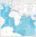
| 16:06, 16 January 2010 |  | 2,070 × 2,129 (6.25 MB) | Dreizung | {{Information |Description={{en|1=Route of German deep-sea Expedition with vessel Valdivia 1898-1899}} {{de|1=Fahrtroute der ersten deutschen Tiefsee-Expedition mit dem Dampfer Valdivia 1898-1899}} |Source=Carl Chun: Aus den Tiefen des Weltmeeres, Gustav |
File usage
The following pages on the English Wikipedia use this file (pages on other projects are not listed):
Global file usage
The following other wikis use this file:
- Usage on de.wikipedia.org
- Usage on es.wikipedia.org
- Usage on www.wikidata.org
