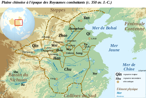
Size of this PNG preview of this SVG file: 568 × 384 pixels. Other resolutions: 320 × 216 pixels | 640 × 433 pixels | 1,024 × 692 pixels | 1,280 × 865 pixels | 2,560 × 1,731 pixels.
Original file (SVG file, nominally 568 × 384 pixels, file size: 732 KB)
File history
Click on a date/time to view the file as it appeared at that time.
| Date/Time | Thumbnail | Dimensions | User | Comment | |
|---|---|---|---|---|---|
| current | 09:21, 16 April 2012 |  | 568 × 384 (732 KB) | Zunkir | Modification des frontières à partir de P. B. Ebrey, The Cambridge Illustrated History of China, Cambridge, 1999. |
| 21:34, 2 March 2012 |  | 568 × 384 (741 KB) | Zunkir | Modifications des frontières. | |
| 21:44, 22 February 2012 |  | 568 × 384 (741 KB) | Zunkir | Modif. frontières Zhao | |
| 21:39, 22 February 2012 |  | 568 × 384 (740 KB) | Zunkir | == {{int:filedesc}} == {{Information |Description={{fr|1=Carte de la plaine Chinoise à l'époque des royaumes combattants (c. 350 av. J.C.)}}{{en|1=Map of the Chinese plain, c. 350 BC. Warring States Period}} |Source={{Derived from|Chinese_plain_5c._BC-f |
File usage
The following 2 pages use this file:
Global file usage
The following other wikis use this file:
- Usage on fr.wikipedia.org
- Usage on lt.wikipedia.org
- Usage on pl.wikipedia.org
- Usage on uk.wikipedia.org