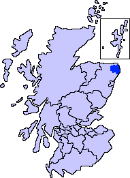
ScotlandAberdeenshireBuchan.png (191 × 261 pixels, file size: 4 KB, MIME type: image/png)
File history
Click on a date/time to view the file as it appeared at that time.
| Date/Time | Thumbnail | Dimensions | User | Comment | |
|---|---|---|---|---|---|
| current | 01:30, 8 November 2007 |  | 191 × 261 (4 KB) | Harami2000 | == Summary == == Summary == {{Information |Description= Aberdeenshire unitary council - Buchan Area |Source= Slightly edited version of a map drawn by Morwen and Voyager |Date= |Author= |Permission= |other_versio |
File usage
The following 39 pages use this file:
- Aden Country Park
- Auchnagatt
- Boddam, Aberdeenshire
- Buchan
- Buchanhaven
- Bullers of Buchan
- Clola
- Crimond
- Crimonmogate
- Cruden Bay
- Deer Abbey
- Downiehills
- Fetterangus
- Formartine and Buchan Way
- Hatton, Aberdeenshire
- Inverugie
- Kirktown of St Fergus
- Loch of Strathbeg
- Longhaven
- Longside
- Lonmay
- Maud, Aberdeenshire
- Mintlaw
- New Deer
- New Leeds
- New Pitsligo
- New Slains Castle
- Old Deer
- Peterhead
- Rattray, Aberdeenshire
- Rattray Head
- Rora, Aberdeenshire
- St Combs
- St Fergus
- Stirling Village
- Strichen
- Stuartfield
- Whinnyfold
- Template:Buchan, Aberdeenshire places
Global file usage
The following other wikis use this file:
- Usage on fa.wikipedia.org
- Usage on fr.wikipedia.org

