No higher resolution available.
ScotlandSouthAyrshire.png (200 × 230 pixels, file size: 4 KB, MIME type: image/png)
| This is a file from the Wikimedia Commons. Information from its description page there is shown below. Commons is a freely licensed media file repository. You can help. |
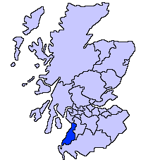
South Ayrshire unitary council
Slightly edited version of a map drawn by Morwen

|
Permission is granted to copy, distribute and/or modify this document under the terms of the GNU Free Documentation License, Version 1.2 or any later version published by the Free Software Foundation; with no Invariant Sections, no Front-Cover Texts, and no Back-Cover Texts. A copy of the license is included in the section entitled GNU Free Documentation License. |
| This file is licensed under the Creative Commons Attribution-Share Alike 3.0 Unported license. | ||
| ||
| This licensing tag was added to this file as part of the GFDL licensing update. |
File history
Click on a date/time to view the file as it appeared at that time.
| Date/Time | Thumbnail | Dimensions | User | Comment | |
|---|---|---|---|---|---|
| current | 21:41, 17 May 2005 | | 200 × 230 (4 KB) | Voyager | |
| 21:40, 17 May 2005 |  | 200 × 230 (4 KB) | Voyager | South Ayrshire unitary council Slightly edited version of a map drawn by Morwen {{GFDL}} Category:Maps of Scottish unitary councils |
File usage
The following 3 pages use this file:
Global file usage
The following other wikis use this file:
- Usage on be.wikipedia.org
- Usage on bg.wikipedia.org
- Usage on cy.wikipedia.org
- Usage on de.wikipedia.org
- Usage on eu.wikipedia.org
- Hegoaldeko Ayrshire
- Ayr
- Lankide:Euskaldunaa
- Maybole
- Prestwick
- Txantiloi:Hegoaldeko Ayrshire
- Wikiproiektu:Irlanda, Gales eta Eskoziako udalerriak
- Alloway
- Girvan
- Troon
- Annbank
- Ballantrae
- Barassie (Hegoaldeko Ayrshire)
- Coylton
- Craigie Udalerria eta Parrokia
- Dundonald (South Ayrshire)
- Failford
- Heronsford
- Joppa (Hegoaldeko Ayrshire)
- Loans (Hegoaldeko Ayrshire)
- Millmannoch
- Monkton (Ayrshire)
- Mossblown
- Old Rome (Hegoaldeko Ayrshire)
- Symington (Hegoaldeko Ayrshire)
- Tarbolton
- Barr (Ayrshire)
- Barrhill (Hegoaldeko Ayrshire)
- Colmonell
- Crosshill (Hegoaldeko Ayrshire)
- Dailly
- Dunure
- Kirkmichael
- Kirkoswald (Hegoaldeko Ayrshire)
- Maidens
- Minishant
- Old Dailly
- Straiton
- Belmont (Ayr)
- Doonfoot
- Montgomerieston
- Heathfield (Hegoaldeko Ayrshire)
- Kincaidston
- Seafield (Ayr)
- Usage on gv.wikipedia.org
- Usage on hr.wikipedia.org
View more global usage of this file.