
Size of this preview: 800 × 527 pixels. Other resolutions: 320 × 211 pixels | 640 × 422 pixels | 1,024 × 675 pixels | 1,280 × 844 pixels | 2,560 × 1,688 pixels | 4,000 × 2,637 pixels.
Original file (4,000 × 2,637 pixels, file size: 7.69 MB, MIME type: image/jpeg)
| This is a file from the Wikimedia Commons. Information from its description page there is shown below. Commons is a freely licensed media file repository. You can help. |
Summary
| Description |
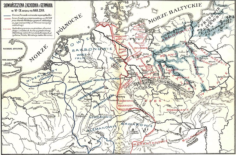
English: The western borders of the Slavic settlement: Hamburg, the Ilmenau River, Braunschweig, the Harz Mountains, Würzburg and Limes Sorabicus, drawn in 808-808 by Charlemagne (the border separating his monarchy from the Western Slavs)
Polski: Zachodnie granice osadnictwa słowiańskiego: Hamburg, rzeka Ilmenau, Braunschweig, góry Harz, Würzburg oraz zakreślony czerwoną linią ciągłą Limes Sorabicus, przeprowadzony w r. 808-808 przez Karola Wielkiego (granica oddzielająca jego monarchię od Słowiańszczyzny zachodniej) Словѣньскъ / ⰔⰎⰑⰂⰡⰐⰠⰔⰍⰟ: ⰃⰓⰀⰐⰋⰜⰀ ⰎⰖⰈⰠⰉⰜⰍⰀ |
| Date | |
| Source | Prahistorja ziem polskich |
| Author | prof. Włodzimierz Dzwonkowski |
Licensing
|
This work is in the public domain in its country of origin and other countries and areas where the copyright term is the author's life plus 70 years or fewer. | |
| This file has been identified as being free of known restrictions under copyright law, including all related and neighboring rights. | |
File history
Click on a date/time to view the file as it appeared at that time.
| Date/Time | Thumbnail | Dimensions | User | Comment | |
|---|---|---|---|---|---|
| current | 05:22, 12 July 2020 | | 4,000 × 2,637 (7.69 MB) | Kriestovo Nysian | Better resolution. |
| 11:22, 8 February 2011 |  | 1,145 × 748 (296 KB) | Bornholm | {{Information |Description ={{en|1=West border Slavs territory in 9 c. and Limes Sorabicus}} {{pl|1=Zachodnie granice osadnictwa słowiańskiego: Hamburg, rzeka Ilmenawa, Brunszwik, góry Harcu, Fulda, Wurzburg, rzeka Wernica oraz zakreślony czerwoną |
File usage
The following pages on the English Wikipedia use this file (pages on other projects are not listed):
Global file usage
The following other wikis use this file:
- Usage on be.wikipedia.org
- Usage on bg.wikipedia.org
- Usage on cs.wikipedia.org
- Usage on de.wikipedia.org
- Usage on de.wikibooks.org
- Usage on de.wikiversity.org
- Usage on dsb.wikipedia.org
- Usage on es.wikipedia.org
- Usage on fr.wikipedia.org
- Usage on it.wikipedia.org
- Usage on lv.wikipedia.org
- Usage on pl.wikipedia.org
- Usage on ro.wikipedia.org
- Usage on ru.wikipedia.org
- Usage on sr.wikipedia.org
- Usage on uk.wikipedia.org