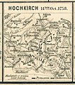
File:Spruner-Menke Handatlas 1880 Karte 46 Nebenkarte 16.jpg

Original file (873 × 986 pixels, file size: 306 KB, MIME type: image/jpeg)

Description Schlachtplan von Hochkirch
Date
Source Karl Spruner von Merz, Heinrich Theodor Menke: Hand-Atlas für die Geschichte des Mittelalters und der neueren Zeit, 3. Auflage. Gotha, Justus Perthes
Author
Heinrich Theodor Menke  (1819–1892)  wikidata:Q14208224
 
Heinrich Theodor Menke
Alternative names
Menke, Th.
Description geographer
Date of birth/death 24 May 1819 Edit this at Wikidata 14 May 1892 Edit this at Wikidata
Location of birth/death Bremen Edit this at Wikidata Gotha Edit this at Wikidata
Authority file
creator QS:P170,Q14208224
Karl Spruner von Merz  (1803–1892)  wikidata:Q6186030 s:it:Autore:Karl Spruner von Merz
 
Alternative names
Karl von Spruner / Carl von Spruner
Description German cartographer and historian
Date of birth/death 15 November 1803 Edit this at Wikidata 24 August 1892 Edit this at Wikidata
Location of birth/death Stuttgart Edit this at Wikidata Munich Edit this at Wikidata
Authority file
creator QS:P170,Q6186030
self scanned from own book
Permission
(Reusing this file)
Public domain

This work is in the public domain in its country of origin and other countries and areas where the copyright term is the author's life plus 100 years or fewer.


This work is in the public domain in the United States because it was published (or registered with the U.S. Copyright Office) before January 1, 1929.

This file has been identified as being free of known restrictions under copyright law, including all related and neighboring rights.

Captions

Add a one-line explanation of what this file represents

Items portrayed in this file

depicts

File history

Click on a date/time to view the file as it appeared at that time.

Date/TimeThumbnailDimensionsUserComment
current15:07, 4 May 2017Thumbnail for version as of 15:07, 4 May 2017873 × 986 (306 KB)Auntieruth55Reverted to version as of 14:55, 4 May 2017 (UTC)
14:57, 4 May 2017Thumbnail for version as of 14:57, 4 May 2017873 × 986 (307 KB)Auntieruth55Reverted to version as of 14:55, 4 May 2017 (UTC)
14:55, 4 May 2017Thumbnail for version as of 14:55, 4 May 2017873 × 986 (306 KB)Auntieruth55Reverted to version as of 14:53, 4 May 2017 (UTC)
14:55, 4 May 2017Thumbnail for version as of 14:55, 4 May 2017873 × 986 (307 KB)Auntieruth55cleaned up, cropped
14:53, 4 May 2017Thumbnail for version as of 14:53, 4 May 2017873 × 986 (306 KB)Auntieruth55cleaned up, cropped
16:46, 22 October 2016Thumbnail for version as of 16:46, 22 October 2016995 × 1,124 (139 KB)A. Wagner{{Information |Description= Schlachtplan von Hochkirch |Source=Karl Spruner von Merz, Heinrich Theodor Menke: ''Hand-Atlas für die Geschichte des Mittelalters und der neueren Zeit'', 3. A...

The following page uses this file:

Global file usage

The following other wikis use this file:

Metadata