
Size of this PNG preview of this SVG file: 493 × 599 pixels. Other resolutions: 197 × 240 pixels | 395 × 480 pixels | 632 × 768 pixels | 843 × 1,024 pixels | 1,686 × 2,048 pixels | 1,042 × 1,266 pixels.
Original file (SVG file, nominally 1,042 × 1,266 pixels, file size: 911 KB)
| This is a file from the Wikimedia Commons. Information from its description page there is shown below. Commons is a freely licensed media file repository. You can help. |
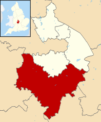
| Description | Map of Warwickshire, with Stratford-on-Avon highlighted. |
| Date | (UTC) |
| Source | |
| Author |
|
.svg)
I, the copyright holder of this work, hereby publish it under the following license:
This file is licensed under the Creative Commons Attribution-Share Alike 3.0 Unported license.
- You are free:
- to share – to copy, distribute and transmit the work
- to remix – to adapt the work
- Under the following conditions:
- attribution – You must give appropriate credit, provide a link to the license, and indicate if changes were made. You may do so in any reasonable manner, but not in any way that suggests the licensor endorses you or your use.
- share alike – If you remix, transform, or build upon the material, you must distribute your contributions under the same or compatible license as the original.
Original upload log
This image is a derivative work of the following images:
- File:Warwickshire UK district map (blank).svg licensed with Cc-by-sa-3.0
- 2010-08-22T08:21:14Z Nilfanion 1042x1266 (931105 Bytes) +inset, water colour tweak
- 2010-07-16T23:57:57Z Nilfanion 1042x1266 (557360 Bytes) {{Information |Description=Map of [[w:Warwickshire|Warwickshire]], UK with districts shown. Equirectangular map projection on WGS 84 datum, with N/S stretched 160% Geographic limits: *West: 2.10W *East: 1.10W *North: 52.70N
File history
Click on a date/time to view the file as it appeared at that time.
| Date/Time | Thumbnail | Dimensions | User | Comment | |
|---|---|---|---|---|---|
| current | 09:14, 13 August 2011 | | 1,042 × 1,266 (911 KB) | Renly~commonswiki | {{Information |Description=Map of Warwickshire, with Stratford-on-Avon highlighted. |Source=*File:Warwickshire UK district map (blank).svg |Date=2011-08-13 09:14 (UTC) |Author=*File:Warwickshire UK district map (blank).svg: [[User:Nilfanion|Ni |
.svg)
File usage
The following page uses this file:
Global file usage
The following other wikis use this file:
- Usage on cy.wikipedia.org
- Usage on es.wikipedia.org
- Usage on fr.wikipedia.org
- Stratford-upon-Avon
- Admington
- Loxley (Warwickshire)
- Kineton
- Gaydon
- Alcester
- Little Compton (Warwickshire)
- Tanworth-in-Arden
- Snitterfield
- Stratford-on-Avon (district)
- Henley-in-Arden
- Studley
- Binton
- Salford Priors
- Southam
- Liste des paroisses civiles du Warwickshire
- Wormleighton
- Wixford
- Wilmcote
- Whichford
- Whatcote
- Tysoe
- Ufton
- Ullenhall
- Watergall
- Welford-on-Avon
- Wellesbourne
- Weston-on-Avon
- Tidmington
- Temple Grafton
- Sutton-under-Brailes
- Stretton-on-Fosse
- Sambourne (Royaume-Uni)
- Shotteswell
- Shipston-on-Stour
- Long Itchington
- Bishop's Itchington
- Harbury
- Farnborough (Warwickshire)
- Great Alne
- Modèle:Palette Stratford-on-Avon
- Alderminster
- Aston Cantlow
- Avon Dassett
- Burton Dassett
- Bearley
- Bidford-on-Avon
- Brailes
View more global usage of this file.