File:Sudeten.jpg

Original file (1,600 × 1,007 pixels, file size: 180 KB, MIME type: image/jpeg)

Summary

Description
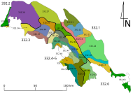
Polski: Sudety - podział na pasma górskie i części (Sudety Zachodnie, S. Środkowe i Wschodnie.
Nr. German Czech RNr. Polish RNr. Commons category
de:Westsudeten cs:Krkonošská oblast/
Zapadní Sudety
pl:Pogórze Zachodniosudeckie 332.2 Western Sudetes Pogórze Zachodniosudeckie
pl:Sudety Zachodnie 332.3 Sudety Zachodnie
1 de:Westlausitzer Hügel- und Bergland cs:Západolužické podhůří pl:Pogórze Zachodniołużyckie 332.21 Westlausitzer Hügel- und Bergland
2 de:Oberlausitzer Gefilde cs:Lužická niva pl:Płaskowyż Budziszyński 332.22 Oberlausitzer Gefilde
3 de:Lausitzer Bergland
Schluckenauer Hügelland
cs:Šluknovská pahorkatina IVA-1 pl:Pogórze Łużyckie 332.24 Šluknovská pahorkatina
4 de:Östliche Oberlausitz ? pl:Pogórze Wschodniołużyckie 332.23 Östliche Oberlausitz
de:Zittauer Becken cs:Žitavská pánev IVA-4 pl:Kotlina Żytawska 332.25 Žitavská pánev
pl:Kotlina Liberecka 332.33
5 de:Lausitzer Gebirge
(einschl. de:Zittauer Gebirge)
cs:Lužické hory
(Žitavské hory)
IVA-2
0
pl:Góry Łużyckie 332.31
0
Lusatian Mountains
(Zittau Mountains)
6 de:Isergebirgs-Vorland cs:Frýdlantská pahorkatina IVA-5 pl:Pogórze Izerskie 332.26 Frýdlantská pahorkatina
Pogórze Izerskie
7 de:Isergebirge cs:Jizerské hory IVA-6 pl:Góry Izerskie 332.34 Jizera Mountains
8 de:Jeschken-Kosakow-Kamm cs:Ještědsko-kozákovský hřbet IVA-3 pl:Grzbiet Jesztiedzki 332.32 Ještědsko-kozákovský hřbet
9 de:Bober-Katzbach-Vorgebirge cs:Kačavské podhůří pl:Pogórze Kaczawskie 332.27 Pogórze Kaczawskie
10 de:Bober-Katzbach-Gebirge cs:Kačavské hory pl:Góry Kaczawskie 332.35 Góry Kaczawskie
11 de:Hirschberger Tal cs:Jelenohorská kotlina pl:Kotlina Jeleniogórska 332.36 Kotlina Jeleniogórska
12 de:Landeshuter Kamm cs:Janovické rudohoří pl:Rudawy Janowickie 332.38 Rudawy Janowickie
13 de:Riesengebirge cs:Krkonoše IVA-7 pl:Karkonosze 332.37 Krkonoše
14 de:Riesengebirgs-Vorland cs:Krkonošské podhůří IVA-8 pl:Pogórze Karkonoskie 332.39 Krkonošské podhůří
15 de:Waldenburger Bergland ? pl:Pogórze Wałbrzyskie 332.28 Pogórze Wałbrzyskie
de:Mittelsudeten cs:Orlická oblast/
(Střední Sudety)
pl:Przedgórze Sudeckie 332.1 Central Sudetes Przedgórze Sudeckie
pl:Sudety Środkowe 332.4–5 Sudety Środkowe
16 de:Striegauer Berge ? pl:Wzgórza Strzegomskie 332.11 Wzgórza Strzegomskie
17 ? ? pl:Obniżenie Podsudeckie 332.15 Obniżenie Podsudeckie
18 ? ? pl:Równina Świdnicka 332.12 Równina Świdnicka
19 de:Zobtengebirge cs:Ślęża pl:Masyw Ślęży 332.13 Masyw Ślęży
20 de:Waldenburger Gebirge cs:Valbřišské hory pl:Góry Wałbrzyskie 332.42 Góry Wałbrzyskie
21 Góry Kamienne
(einschl. de:Rabengebirge)
cs:Góry Kamienne
(cs:Vraní hory)
IVB-1[1]
0
pl:Góry Kamienne
(pl:Góry Krucze)
332.43
0
Góry Kamienne
(Vraní hory)
22 de:Liebauer Tor cs:Lubavská brána IVB-1[1] pl:Brama Lubawska 332.41 Brama Lubawska
23 de:Eulengebirge cs:Soví hory pl:Góry Sowie 332.44 Góry Sowie
24 de:Neuroder Senke ? pl:Obniżenie Noworudzkie 332.46 Obniżenie Noworudzkie
25 de:Steinetal cs:Broumovská kotlina IVB-1[1] pl:Obniżenie Ścinawki 332.47 Obniżenie Ścinawki
26 de:Heuscheuergebirge cs:Stolové hory IVB-1[1] pl:Góry Stołowe 332.48 Góry Stołowe
27 ? ? pl:Wzgórza Niemczańsko-Strzelińskie 332.14 Wzgórza Niemczańsko-Strzelińskie
28 de:Weidenauer Tiefland ? pl:Obniżenie Otmuchowskie 332.16 Obniżenie Otmuchowskie
29 de:Weidenauer Hügelland cs:Vidnavská nížina IVD-1 pl:Przedgórze Paczkowskie 332.17 Vidnavská nížina Przedgórze Paczkowskie
30 de:Friedeberger Bergland cs:Žulovská pahorkatina IVD-2 Žulovská pahorkatina
31 de:Warthagebirge cs:Bardské hory pl:Góry Bardzkie 332.45 Góry Bardzkie
32 de:Glatzer Kessel cs:Kladská kotlina IVB-4 pl:Kotlina Kłodzka 332.54 Kotlina Kłodzka
33a de:Adlergebirge cs:Orlické hory IVB-2 pl:Góry Orlickie 332.52 Orlické hory
33b de:Habelschwerdter Gebirge cs:Bystřické hory pl:Góry Bystrzyckie 332.53 Góry Bystrzyckie
34 de:Adlervorgebirge cs:Podorlická pahorkatina IVB-3 pl:Pogórze Orlickie 332.51 Podorlická pahorkatina
de:Ostsudeten cs:Jesenická oblast/
(Východní Sudety)
pl:Sudety Wschodnie 332.6 Eastern Sudetes
35 de:Reichensteiner Gebirge cs:Rychlebské hory IVC-5 pl:Góry Złote 332.61 Góry Złote
36 de:Glatzer Schneegebirge
cs:Králický Sněžník IVC-4 pl:Masyw Śnieżnika 332.62 Masyw Śnieżnika
37 de:Oppagebirge cs:Zlatohorská vrchovina IVC-6 pl:Góry Opawskie 332.63 Góry Opawskie
38 de:Altvatergebirge cs:Hrubý Jeseník IVC-7 pl:Wysoki Jesionik 332.65 Hrubý Jeseník
39 de:Hannsdorfer Bergland cs:Hanušovická vrchovina IVC-3 pl:Hanušovická vrchovina 332.64 Hanušovická vrchovina
40 de:Müglitzer Furche cs:Mohelnická brázda IVC-2 pl:Mohelnická brázda 332.67 Mohelnická brázda
41 de:Hohenstädter Bergland cs:Zábřežská vrchovina IVC-1 pl:Wyżyna Zabrzeska 332.68 Zábřežská vrchovina
42 de:Niederes Gesenke cs:Nízký Jeseník IVC-8 pl:Niski Jesionik 332.66 Nízký Jeseník

Original legend copied from de:Sudeten#Gliederung (copy date was 2009)

Notes:

  1. a b c d The Czech names for Nr. 21 (Góry Kamienne), 22 (Lubavská brána), 25 (Broumovská kotlina) and 26 (Stolové hory) are names for landscapes. The Czech parts of these landscapes are geomorphologicaly put together under different names in one region called cs:Broumovská vrchovina IVB-1 (pl:Broumovská vrchovina, de:Braunauer Bergland).
Date
Source Own work
Author Meichs
Other versions Czech: Sudety.png
File:Sudeten m.svg is a vector version of this file. It should be used in place of this JPG file when not inferior.

File:Sudeten.jpg → File:Sudeten m.svg

For more information, see Help:SVG.

In other languages
Alemannisch  Bahasa Indonesia  Bahasa Melayu  British English  català  čeština  dansk  Deutsch  eesti  English  español  Esperanto  euskara  français  Frysk  galego  hrvatski  Ido  italiano  lietuvių  magyar  Nederlands  norsk bokmål  norsk nynorsk  occitan  Plattdüütsch  polski  português  português do Brasil  română  Scots  sicilianu  slovenčina  slovenščina  suomi  svenska  Tiếng Việt  Türkçe  vèneto  Ελληνικά  беларуская (тарашкевіца)  български  македонски  нохчийн  русский  српски / srpski  татарча/tatarça  українська  ქართული  հայերեն  বাংলা  தமிழ்  മലയാളം  ไทย  한국어  日本語  简体中文  繁體中文  עברית  العربية  فارسی  +/−
New SVG image

Licensing

GNU head Permission is granted to copy, distribute and/or modify this document under the terms of the GNU Free Documentation License, Version 1.2 or any later version published by the Free Software Foundation; with no Invariant Sections, no Front-Cover Texts, and no Back-Cover Texts. A copy of the license is included in the section entitled GNU Free Documentation License.
w:en:Creative Commons
attribution share alike
This file is licensed under the Creative Commons Attribution-Share Alike 3.0 Unported license.
You are free:
  • to share – to copy, distribute and transmit the work
  • to remix – to adapt the work
Under the following conditions:
  • attribution – You must give appropriate credit, provide a link to the license, and indicate if changes were made. You may do so in any reasonable manner, but not in any way that suggests the licensor endorses you or your use.
  • share alike – If you remix, transform, or build upon the material, you must distribute your contributions under the same or compatible license as the original.
This licensing tag was added to this file as part of the GFDL licensing update.

Captions

Add a one-line explanation of what this file represents

Items portrayed in this file

depicts

18 May 2007

File history

Click on a date/time to view the file as it appeared at that time.

Date/TimeThumbnailDimensionsUserComment
current13:02, 19 May 2007Thumbnail for version as of 13:02, 19 May 20071,600 × 1,007 (180 KB)Meichs~commonswiki{{Information |Description=Sudety |Source=selbst erstellt |Date=18.05.2007 |Author=Meichs |Permission= |other_versions= }} Category:Maps of Germany Category:Maps of the Czech Republic Category:Maps of Poland
No pages on the English Wikipedia use this file (pages on other projects are not listed).

Global file usage

The following other wikis use this file:

Metadata