File:TenjosanAeralphTyoJp1978-01.jpg

Original file (847 × 843 pixels, file size: 172 KB, MIME type: image/jpeg)

Summary

Description

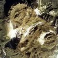
Aerial Photo of top of Mt. Tenjosan, Kozushimamura, Tokyo, Japan.

日本語: 東京都神津島村。伊豆諸島の神津島の最高峰、天上山の山頂付近の航空写真。1978年度撮影。中央の斜めの白い部分が、「表砂漠」。その右の白い部分が「裏砂漠」。逆に左のY字形の白い部分の二股に挟まれたあたりが、三角点である。画面下中央の白い点が「千代池」(せんだいいけ)。画面上中央の白い丸が「不動池」。左の谷は神津沢。
Date
Source
Author
日本語: 国土交通省

Licensing

© The copyright holder of this file, the Ministry of Land, Infrastructure, Transport and Tourism of Japan, allows anyone to use it for any purpose, provided that the copyright holder is properly attributed. Redistribution, derivative work, commercial use, and all other use is permitted.
Attribution:
Copyright © National Land Image Information (Color Aerial Photographs), Ministry of Land, Infrastructure, Transport and Tourism

Notice
This image is copyrighted by the Ministry of Land, Infrastructure, Transport and Tourism of Japan. For terms of use, see the stipulation to use of National Land Information (in Japanese) and message from MLIT (in Japanese and English). When you display this image on an article, include the following phrase in the description: "Made based on National Land Image Information (Color Aerial Photographs), Ministry of Land, Infrastructure, Transport and Tourism".

Captions

Add a one-line explanation of what this file represents

Items portrayed in this file

depicts

176,608 byte

843 pixel

847 pixel

image/jpeg

e14389541df278a72e7b9e4bf280c31c90bbfe19

File history

Click on a date/time to view the file as it appeared at that time.

Date/TimeThumbnailDimensionsUserComment
current13:27, 4 January 2005Thumbnail for version as of 13:27, 4 January 2005847 × 843 (172 KB)Aerial Photo of top of Mt. Tenjosan, Kozushimamura, Tokyo, Japan. 1978/79 {{GFDL-AeralPhoto-MlitJp}}

The following page uses this file:

Global file usage

The following other wikis use this file:

Metadata