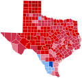
Size of this PNG preview of this SVG file: 631 × 599 pixels. Other resolutions: 253 × 240 pixels | 506 × 480 pixels | 809 × 768 pixels | 1,079 × 1,024 pixels | 2,157 × 2,048 pixels | 810 × 769 pixels.
Original file (SVG file, nominally 810 × 769 pixels, file size: 104 KB)
File history
Click on a date/time to view the file as it appeared at that time.
| Date/Time | Thumbnail | Dimensions | User | Comment | |
|---|---|---|---|---|---|
| current | 23:15, 29 February 2024 |  | 810 × 769 (104 KB) | Putitonamap98 | shapes county lines of two costal counties were different pre 1975 |
| 00:23, 1 June 2023 |  | 810 × 769 (104 KB) | CrookCoMaps61 | Shapes | |
| 11:07, 30 May 2023 |  | 344 × 336 (55 KB) | Tinpo162 | Reverted to version as of 05:15, 8 July 2020 (UTC) | |
| 21:34, 23 May 2023 |  | 322 × 315 (117 KB) | Tinpo162 | Reverted to version as of 02:12, 31 December 2016 (UTC) | |
| 05:15, 8 July 2020 |  | 344 × 336 (55 KB) | TylerKutschbach | Better map. | |
| 02:12, 31 December 2016 |  | 322 × 315 (117 KB) | WikiBunny2K1 | Thicker lines | |
| 01:51, 31 December 2016 |  | 322 × 315 (117 KB) | WikiBunny2K1 | Thicker lines | |
| 01:28, 31 December 2016 |  | 322 × 315 (103 KB) | WikiBunny2K1 | Cross-wiki upload from en.wikipedia.org |
File usage
The following page uses this file:
Global file usage
The following other wikis use this file:
- Usage on fr.wikipedia.org
- Usage on ko.wikipedia.org