
Size of this PNG preview of this SVG file: 800 × 370 pixels. Other resolutions: 320 × 148 pixels | 640 × 296 pixels | 1,024 × 474 pixels | 1,280 × 593 pixels | 2,560 × 1,185 pixels | 1,268 × 587 pixels.
Original file (SVG file, nominally 1,268 × 587 pixels, file size: 527 KB)
| This is a file from the Wikimedia Commons. Information from its description page there is shown below. Commons is a freely licensed media file repository. You can help. |
Summary
| Description |
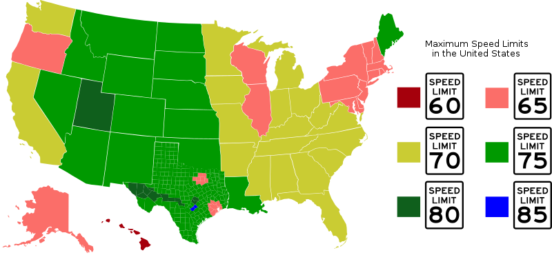
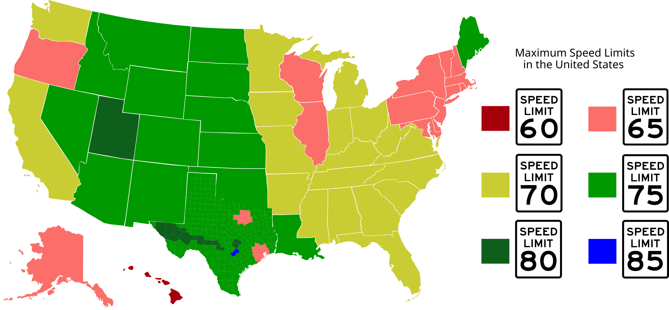
Top speed limits in the United States; lightest red color (Hawaii) is 60 mph, darkest green color (certain counties in Texas) is 80 mph. Entire state is one color if the top speed limit is broadly applicable. States may be graphically split into regions if different top speed limits exist in substantially-sized regions (generally larger than urban areas). From Blank_US_Map.svg (by Wikicommons user Theshibboleth) and Texas county map, also available on Wikipedia. Map colored by Shadowlink1014 and novasource. |
| Date | 18 March 2007 (original upload date) |
| Source | Transferred from en.wikipedia to Commons. |
| Author |
Shadowlink1014 at English Wikipedia Later versions were uploaded by Novasource at en.wikipedia. |
| Other versions | Derivative works of this file: US speed limits12.png |
Licensing
Shadowlink1014 at English Wikipedia, the copyright holder of this work, hereby publishes it under the following license:
| This file is licensed under the Creative Commons Attribution-Share Alike 3.0 Unported license. Subject to disclaimers. | ||
| Attribution: Shadowlink1014 at English Wikipedia | ||
| ||
| This licensing tag was added to this file as part of the GFDL licensing update. |

|
Permission is granted to copy, distribute and/or modify this document under the terms of the GNU Free Documentation License, Version 1.2 or any later version published by the Free Software Foundation; with no Invariant Sections, no Front-Cover Texts, and no Back-Cover Texts. A copy of the license is included in the section entitled GNU Free Documentation License. Subject to disclaimers. |
Original upload log
The original description page was here. All following user names refer to en.wikipedia.
- 2007-04-28 02:10 Novasource 1300×593×0 (828888 bytes) Probably more correct interpretation of Virginia. In fact, max limit is 65 except for one small interstate.
- 2007-03-24 22:15 Shadowlink1014 1300×593×0 (828630 bytes) Top speed limits in the United States; darkest red color (Hawaii) is 60 mph, darkest green color (certain counties in Texas) is 80 mph. From Blank_US_Map.svg (by Wikicommons user Theshibboleth) and Texas county map, also available on Wikipedia. Map colo
- 2007-03-24 22:11 Shadowlink1014 1300×593×0 (828617 bytes) Top speed limits in the United States; darkest red color (Hawaii) is 60 mph, darkest green color (certain counties in Texas) is 80 mph. From Blank_US_Map.svg (by Wikicommons user Theshibboleth) and Texas county map, also available on Wikipedia. Map colo
- 2007-03-23 18:31 Novasource 1300×593×0 (828617 bytes) More corrections based on discussion with others.
- 2007-03-23 14:18 Novasource 1300×593×0 (828617 bytes) Fixed some Texas counties based on input of a person who had recently driven them. It should be noted that anecdotal experience suggests only a fraction of the eligible counties (the red ones at http://home.att.net/~texhwyman/h_imgs/txpopdens.jpg) have sp
- 2007-03-23 02:42 Novasource 1300×593×0 (631706 bytes) Newer version that incorporates individual Texas counties. Shows how little of Texas really is effected by the 80 mph speed limits. A more accurate version would have all the west Texas counties with 75 mph highlighting and thin lines to show I-20 and I-1
- 2007-03-18 21:33 Shadowlink1014 1300×593×0 (151903 bytes) Top speed limits in the United States; lightest color (Hawaii) is 60 mph, darkest color (Texas) is 80 mph. From Blank_US_Map.svg (by Wikicommons user Theshibboleth). Map colored by Shadowlink1014. == Licensing == {{self|GFDL}}
- 2007-03-18 21:26 Shadowlink1014 1300×593×0 (151314 bytes) Top speed limits in the United States. From Blank_US_Map.svg (by Wikicommons user Theshibboleth). Speed limit sign SVGs from WikiCommons. Data source: [[Speed limits in the United States]] Map colored by Shadowlink1014. == Licensing == {{self|GFDL}}
- 2007-03-18 20:48 Shadowlink1014 959×593×0 (90602 bytes) Top speed limits in the United States; lightest color (Hawaii) is 60 mph, darkest color (Texas) is 80 mph. From Blank_US_Map.svg (by Wikicommons user Theshibboleth). Map colored by Shadowlink1014. == Licensing == {{self|GFDL}}
File history
Click on a date/time to view the file as it appeared at that time.
| Date/Time | Thumbnail | Dimensions | User | Comment | |
|---|---|---|---|---|---|
| current | 16:03, 4 September 2012 | | 1,268 × 587 (527 KB) | Novasource | Oops, prior version was cropped. |
| 16:01, 4 September 2012 |  | 744 × 1,052 (527 KB) | Novasource | Added 85 mph zones in Texas. Only 2 counties have roads with it. (Possibly a TINY portion of the 85 mph road is in Travis County, but that county needs to stay at green.) | |
| 01:24, 15 May 2012 |  | 1,300 × 593 (512 KB) | Novasource | Added 2 more Texas counties, fixed made all 80 mph parts and the legend the same color, and made Hawaii (60 mph) a deep red color to not confuse with 70 mph. | |
| 03:17, 11 February 2012 |  | 1,300 × 593 (512 KB) | Novasource | Newer version that shows Texas as mostly 75 mph now that most Texas rural interstates will be 75 mph. | |
| 02:22, 8 September 2011 |  | 1,300 × 593 (483 KB) | Mets501 | Maximum posted speed limits by state. Updated Utah with 80 MPH maximum posted speed limit (on I-15), Louisiana with 75 MPH maximum posted speed limit (on I-49), and Maine with maximum posted speed limit of 75 MPH (on I-95). Updated by [[:en:User:Wxstorm] | |
| 03:49, 28 June 2011 |  | 1,300 × 593 (482 KB) | Shadowlink1014~commonswiki | Change Kansas to 75mph for state-wide changes starting July 1st; revert Utah back to 75mph since there are only a couple of short 80mph zones on one freeway. Keep Louisiana at 70mph for same reason. Fix title text font. | |
| 20:07, 23 April 2011 |  | 1,300 × 593 (696 KB) | Pgp688~commonswiki | Updating new speed limits in Utah and Ohio | |
| 11:24, 2 November 2010 |  | 1,300 × 593 (690 KB) | Wthrwyz | Updated Virginia to 70, as VDOT has begun signing 70 zones throughout the state. | |
| 06:48, 29 August 2008 |  | 1,300 × 593 (810 KB) | Lordsutch | {{Information |Description=Top speed limits in the United States; lightest red color (Hawaii) is 60 mph, darkest green color (certain counties in Texas) is 80 mph. Entire state is one color if the top speed limit is broadly applicable. States may be grap | |
| 06:24, 1 September 2007 |  | 1,300 × 593 (809 KB) | Mets501 | update thanks to w:User:Novasource |
File usage
The following pages on the English Wikipedia use this file (pages on other projects are not listed):
Global file usage
The following other wikis use this file:
- Usage on he.wikivoyage.org