File:Upper end of Cow Island, in the Missouri, below the mouth of Cow Creek, Missouri Breaks, Motnana.JPG

Size of this preview: 800 × 600 pixels. Other resolutions: 320 × 240 pixels | 640 × 480 pixels | 1,024 × 768 pixels.
Original file (1,024 × 768 pixels, file size: 364 KB, MIME type: image/jpeg)
| This is a file from the Wikimedia Commons. Information from its description page there is shown below. Commons is a freely licensed media file repository. You can help. |
Summary
| Description |
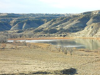
English: This is a view of the upper end of Cow Island, in the Missouri. It lies just below the mouth of Cow Creek. The island is created from sediments washing out from Cow Creek in flood season. This is one of the larger islands in the Missouri. It forms a natural crossing point on the Missouri. During the steamboat era (1860 to the mid 1880's) the Missouri was the path way to the mines in western Montana. Above this point the Missouri had many rapids. In the summer and fall, the river levels dropped, and steamboats could not get up to Ft. Benton, the up river terminus. They had to drop their cargos here. This area became known as Cow Island Landing. The freight was then north and west hauled up Cow Creek, through the Missouri Breaks and out onto the northern Montana plains and on to Ft. Benton. In ancient times Cow Island was a Missouri River crossing point for bison and nomadic Indians. Now the bison and Indians are gone, as are the steamboats. Cow Island lies in a remote and isolated area of the Missouri Breaks in Montana. |
| Date | |
| Source | Own work |
| Author | Montana Geographic Society |
| Camera location | | View this and other nearby images on: OpenStreetMap |
|---|
Licensing
I, the copyright holder of this work, hereby publish it under the following licenses:
This file is licensed under the Creative Commons Attribution-Share Alike 3.0 Unported license.
- You are free:
- to share – to copy, distribute and transmit the work
- to remix – to adapt the work
- Under the following conditions:
- attribution – You must give appropriate credit, provide a link to the license, and indicate if changes were made. You may do so in any reasonable manner, but not in any way that suggests the licensor endorses you or your use.
- share alike – If you remix, transform, or build upon the material, you must distribute your contributions under the same or compatible license as the original.

|
Permission is granted to copy, distribute and/or modify this document under the terms of the GNU Free Documentation License, Version 1.2 or any later version published by the Free Software Foundation; with no Invariant Sections, no Front-Cover Texts, and no Back-Cover Texts. A copy of the license is included in the section entitled GNU Free Documentation License. |
You may select the license of your choice.
File history
Click on a date/time to view the file as it appeared at that time.
| Date/Time | Thumbnail | Dimensions | User | Comment | |
|---|---|---|---|---|---|
| current | 19:51, 16 April 2024 | | 1,024 × 768 (364 KB) | Beao | Removed watermark |
| 04:40, 13 December 2009 |  | 1,024 × 768 (239 KB) | MontGeogSoc | {{Information |Description={{en|1=This is a view of the upper end of Cow Island, in the Missouri. It lies just below the mouth of Cow Creek. The island is created from sediments washing out from Cow Creek in flood season. This is one of the larger isla |
File usage
The following pages on the English Wikipedia use this file (pages on other projects are not listed):
Global file usage
The following other wikis use this file:
- Usage on zh.wikipedia.org