.jpg)
.jpg&action=edit&redlink=1)

Size of this preview: 500 × 599 pixels. Other resolutions: 200 × 240 pixels | 401 × 480 pixels | 641 × 768 pixels | 855 × 1,024 pixels | 1,574 × 1,886 pixels.
Original file (1,574 × 1,886 pixels, file size: 600 KB, MIME type: image/jpeg)
| This is a file from the Wikimedia Commons. Information from its description page there is shown below. Commons is a freely licensed media file repository. You can help. |
.jpg)
Summary
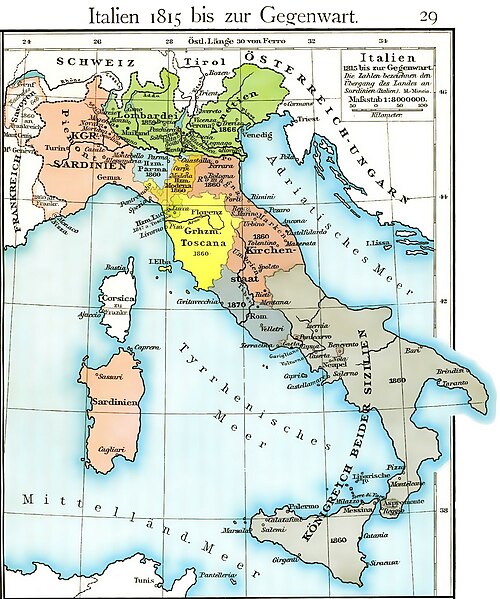
| Description | Cartina dell'unificazione d'Italia dal 1815 fino al 1870 (il ducato di Massa e Carrara, ufficialmente indipendente fino al 1829, non è però indicato, e, non correttamente, è già considerato parte del ducato di Modena fin dal 1815) |
| Date | |
| Source | Historischer Schulatlas di F. W Putzger (1814--1913) Plate 29 from F. W. Putzgers Historischer Schul-Atlas |
| Author | F. W Putzger (1814--1913) |
| Other versions | File:Italy unification 1815 1870.jpg |
derivative works
Derivative works of this file: Italy1816cs.png Putzger, Historischer Schul-Atlas di F. W Putzger (1814--1913).
Licensing
|
This work is in the public domain in its country of origin and other countries and areas where the copyright term is the author's life plus 70 years or fewer. | |
| This file has been identified as being free of known restrictions under copyright law, including all related and neighboring rights. | |
File history
Click on a date/time to view the file as it appeared at that time.
| Date/Time | Thumbnail | Dimensions | User | Comment | |
|---|---|---|---|---|---|
| current | 12:40, 19 March 2011 | | 1,574 × 1,886 (600 KB) | A7N8X | cleared from the watermark image, improved compression. jpeg, making it progressively improving and quick viewing |
| 15:33, 22 January 2009 |  | 1,640 × 1,971 (1,007 KB) | MegaMatic | {{PD-old}} | |
| 11:34, 23 May 2006 |  | 1,640 × 1,971 (1.05 MB) | Massimo Macconi | Cartina dell'Italia nel 1815 tratta da Historisches Schulatlas di F. W Putzgers (1814--1913) |
File usage
The following pages on the English Wikipedia use this file (pages on other projects are not listed):
Global file usage
The following other wikis use this file:
- Usage on af.wikipedia.org
- Usage on als.wikipedia.org
- Usage on ast.wikipedia.org
- Usage on br.wikipedia.org
- Usage on ca.wikipedia.org
- Usage on de.wikipedia.org
- Usage on fr.wikipedia.org
- Usage on hu.wikipedia.org
- Usage on it.wikipedia.org
- Usage on la.wikipedia.org
- Usage on nl.wikipedia.org
- Usage on pl.wikipedia.org
- Usage on scn.wikipedia.org
- Usage on sk.wikipedia.org
- Usage on vec.wikipedia.org
- Usage on www.wikidata.org
.jpg)