Vallard_map_rotated.jpg (795 × 599 pixels, file size: 149 KB, MIME type: image/jpeg)
| This is a file from the Wikimedia Commons. Information from its description page there is shown below. Commons is a freely licensed media file repository. You can help. |

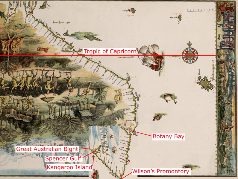
The 1542 Vallard map, with part of the bottom area rotated at 90 degrees, in the same way as described as done by journalist Peter Trickett [1] The image labelled with the claimed modern day locations shown on the map.
It should be noted that the latitude this would give for Wilson's Promontory using the scale visible on the right hand side of the map is 54°S (see: 54°S 145°E / 54°S 145°E) which is far to the south of Tasmania; when Wilson's Promontory is only at 39°S (39°02′S 146°23′E / 39.033°S 146.383°E). The claimed Botany Bay also appears at 43°S which is as far south as Hobart (see: 43°S 147°E / 43°S 147°E), when it is actually only at 33°S (33°58′S 151°10′E / 33.967°S 151.17°E)
|
This work is in the public domain in its country of origin and other countries and areas where the copyright term is the author's life plus 70 years or fewer. | |
| This file has been identified as being free of known restrictions under copyright law, including all related and neighboring rights. | |
File history
Click on a date/time to view the file as it appeared at that time.
| Date/Time | Thumbnail | Dimensions | User | Comment | |
|---|---|---|---|---|---|
| current | 08:59, 23 March 2007 | | 795 × 599 (149 KB) | Roke~commonswiki | The 1542 Vallard map, with part of the bottom area rotated at 90 degrees, in the same way as described as done by journalist Peter Trickett [http://www.smh.com.au/news/national/rotated-map-puts-a-twist-in-the-foundation- |
File usage
Global file usage
The following other wikis use this file:
- Usage on fr.wikipedia.org
- Usage on id.wikipedia.org
- Usage on it.wikipedia.org