No higher resolution available.
Woodilee_Asylum_-_geograph.org.uk_-_441329.jpg (640 × 480 pixels, file size: 115 KB, MIME type: image/jpeg)
| This is a file from the Wikimedia Commons. Information from its description page there is shown below. Commons is a freely licensed media file repository. You can help. |
Summary
| Description |
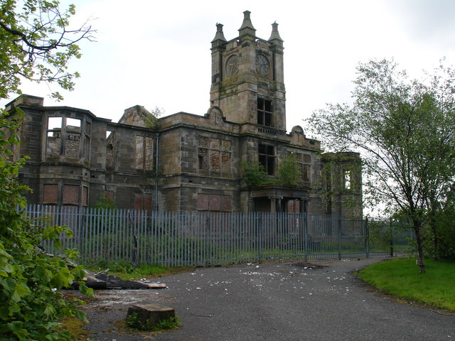
English: Woodilee Asylum Now just a shell, the central building and clock tower along with a few ancillary buildings are all that remain of this previously impressive structure.
Opened in 1875 as the Barony Parochial Asylum at Woodilee it was the largest asylum in Scotland, with 400 inmates. It closed its doors finally in 2001, after cracks appeared in the main block and the patients were evacuated on 'Black Friday (13th March 1987). There are plans to begin developing the site and incorporating parts of the original buildings in 2008-9. |
| Date | |
| Source | From geograph.org.uk |
| Author | Raymond Okonski |
| Attribution (required by the license) | Raymond Okonski / Woodilee Asylum / |
| Camera location | | View this and other nearby images on: OpenStreetMap |
|---|
_heading:202.00&language=en)
| Object location | | View this and other nearby images on: OpenStreetMap |
|---|
_heading:202.00&language=en)
Licensing

|
This image was taken from the Geograph project collection. See this photograph's page on the Geograph website for the photographer's contact details. The copyright on this image is owned by Raymond Okonski and is licensed for reuse under the Creative Commons Attribution-ShareAlike 2.0 license.
|
This file is licensed under the Creative Commons Attribution-Share Alike 2.0 Generic license.
Attribution: Raymond Okonski
- You are free:
- to share – to copy, distribute and transmit the work
- to remix – to adapt the work
- Under the following conditions:
- attribution – You must give appropriate credit, provide a link to the license, and indicate if changes were made. You may do so in any reasonable manner, but not in any way that suggests the licensor endorses you or your use.
- share alike – If you remix, transform, or build upon the material, you must distribute your contributions under the same or compatible license as the original.
File history
Click on a date/time to view the file as it appeared at that time.
| Date/Time | Thumbnail | Dimensions | User | Comment | |
|---|---|---|---|---|---|
| current | 13:14, 4 February 2011 | | 640 × 480 (115 KB) | GeographBot | == {{int:filedesc}} == {{Information |description={{en|1=Woodilee Asylum Now just a shell, the central building and clock tower along with a few ancillary buildings are all that remain of this previously impressive structure. Opened in 1875 as the Baro |
File usage
The following page uses this file:
Global file usage
The following other wikis use this file:
- Usage on arz.wikipedia.org
- Usage on www.wikidata.org