Size of this preview: 800 × 405 pixels. Other resolutions: 320 × 162 pixels | 640 × 324 pixels | 1,024 × 518 pixels | 1,280 × 648 pixels | 2,560 × 1,296 pixels | 4,972 × 2,517 pixels.
Original file (4,972 × 2,517 pixels, file size: 679 KB, MIME type: image/png)
File history
Click on a date/time to view the file as it appeared at that time.
| Date/Time | Thumbnail | Dimensions | User | Comment | |
|---|---|---|---|---|---|
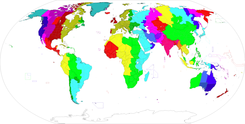
| current | 00:55, 15 October 2024 |  | 4,972 × 2,517 (679 KB) | Heitordp | Updated Chihuahua, Greenland, Paraguay, Egypt, South Sudan, Volgograd, Kazakhstan; corrected various islands; adjusted Canada, Western Australia, Golan Heights |
| 02:59, 9 March 2024 |  | 4,972 × 2,517 (632 KB) | Tcfc2349 | fixed | |
| 11:54, 30 October 2022 |  | 4,972 × 2,517 (679 KB) | Heitordp | Updated Fiji, Iran, Jordan, Syria, Mexico; adjusted Brazil, Canada, Greenland | |
| 03:14, 23 September 2021 |  | 4,972 × 2,517 (682 KB) | AKS471883 | Samoa has scrapped DST https://www.timeanddate.com/news/time/samoa-removes-dst.html | |
| 13:18, 1 February 2021 |  | 4,972 × 2,517 (682 KB) | AKS471883 | South Sudan | |
| 02:02, 1 January 2021 |  | 4,972 × 2,517 (682 KB) | AKS471883 | 2020.12.27 | |
| 14:31, 21 March 2020 |  | 4,972 × 2,517 (682 KB) | AKS471883 | Yukon | |
| 02:45, 6 September 2019 |  | 4,972 × 2,517 (682 KB) | AKS471883 | Norfolk Island Back on Daylight Saving Time | |
| 13:30, 28 July 2019 |  | 4,972 × 2,517 (682 KB) | TerraCyprus | colored ocean areas should be discussed. Looks weird in English WP articles. // Reverted to version as of 11:40, 14 May 2019 (UTC) | |
| 01:32, 28 June 2019 |  | 4,974 × 2,517 (606 KB) | Nucleep | Reverted to version as of 13:51, 10 April 2019 (UTC) - "current" version of map was actually the outdated version |
File usage
The following 3 pages use this file:
Global file usage
The following other wikis use this file:
- Usage on ar.wikipedia.org
- Usage on azb.wikipedia.org
- شابلون:دونیانین ایستاندارد زمانی
- دونیانین ایستاندارد زامانی
- یوتیسی ۳:۳۰+
- یوتیسی ۴:۰۰+
- یوتیسی ۱۱:۰۰-
- یوتیسی ۱۰:۳۰-
- یوتیسی ۲:۳۰-
- یوتیسی ۲:۰۰-
- یوتیسی ۱:۰۰-
- یوتیسی ۰:۴۴-
- یوتیسی ۰:۲۵:۲۱-
- یوتیسی ۰۰:۰۰±
- یوتیسی ۰:۲۰+
- یوتیسی ۰:۳۰+
- یوتیسی ۱:۰۰+
- یوتیسی ۱:۲۴+
- یوتیسی ۱:۳۰+
- یوتیسی ۲:۰۰+
- یوتیسی ۲:۳۰+
- یوتیسی ۳:۰۰+
- یوتیسی ۴:۳۰+
- یوتیسی ۴:۵۱+
- یوتیسی ۵:۰۰+
- یوتیسی ۵:۳۰+
- یوتیسی ۵:۴۰+
- یوتیسی ۵:۴۵+
- یوتیسی ۰۶:۰۰+
- یوتیسی ۶:۳۰+
- یوتیسی ۷:۰۰+
- یوتیسی ۷:۲۰+
- یوتیسی ۷:۳۰+
- یوتیسی ۸:۰۰+
- یوتیسی ۸:۳۰+
- یوتیسی ۸:۴۵+
- یوتیسی ۹:۰۰+
- یوتیسی ۹:۳۰+
- یوتیسی ۹:۴۵+
- یوتیسی ۱۰:۰۰+
- یوتیسی ۱۰:۳۰+
- یوتیسی ۱۱:۰۰+
- یوتیسی ۱۱:۳۰+
- یوتیسی ۱۲:۰۰+
- یوتیسی ۱۲:۴۵+
- یوتیسی ۱۳:۰۰+
- یوتیسی ۱۳:۴۵+
- یوتیسی ۱۴:۰۰+
View more global usage of this file.

