Gretna is a city in Sarpy County, Nebraska, United States. The population was 9,071 at the 2022 census.[6]
Gretna, Nebraska | |
|---|---|
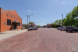
 Downtown looking south on McKenna Avenue, May 2017 | |
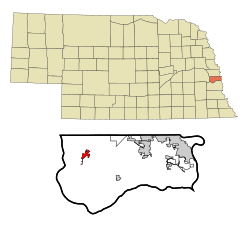
 Location of Gretna, Nebraska | |
| Coordinates: 41°08′27″N 96°14′23″W / 41.14083°N 96.23972°W | |
| Country | United States |
| State | Nebraska |
| County | Sarpy |
| Founded | Summer of 1886 |
| Incorporated | July 10, 1889 |
| Government | |
| • Mayor | Mike Evans |
| Area | |
• Total | 7.049 sq mi (18.257 km2) |
| • Land | 6.951 sq mi (18.003 km2) |
| • Water | 0.097 sq mi (0.251 km2) |
| Elevation | 1,112 ft (339 m) |
| Population | |
• Total | 5,083 |
• Estimate (2023)[4] | 9,054 |
| • Density | 1,302/sq mi (502.8/km2) |
| Time zone | UTC–6 (Central (CST)) |
| • Summer (DST) | UTC–5 (CDT) |
| ZIP Code | 68028 |
| Area code(s) | 402 and 531 |
| FIPS code | 31-20260 |
| GNIS feature ID | 2394248[2] |
| Sales tax | 7.5%[5] |
| Website | gretnane.org |
History
editGretna started shortly after the Burlington Railroad built a short line between Omaha and Ashland in the summer of 1886.[7] Advent of the village of Gretna on this new laid rail line was the cue for the exit of the nearby trading post of Forest City, which had existed since 1856. In its day, Forest City, located 2.5 miles southwest of where Gretna now stands, was a flourishing and busy place, but it was doomed by the railroad which passed it by. The only markers that exist today to show the site of old Forest City is the cemetery (Holy Sepulchre) which is located a little to the east of what was the center of activity in the settlement and the 1886 homestead originally owned by the Schnack Family and located on Schnack Acres at 234th St. Names that were prominent in the beginnings of Forest City were the families of Adolph Schnack, William Langdon, John Thomas and John Conner.
The Lincoln Land Company, recognizing the potential of the site, surveyed and platted the town site of Gretna in 1887. The village was incorporated by July 10, 1889. The name suggests Scotland's Gretna Green,[8] the ancestral county of some of the earliest settlers.
Geography
editAccording to the United States Census Bureau, the city has a total area of 7.049 square miles (18.26 km2), of which 6.951 square miles (18.00 km2) is land and 0.097 square miles (0.25 km2) is water.[1]
Demographics
edit| Census | Pop. | Note | %± |
|---|---|---|---|
| 1890 | 255 | — | |
| 1900 | 466 | 82.7% | |
| 1910 | 484 | 3.9% | |
| 1920 | 491 | 1.4% | |
| 1930 | 477 | −2.9% | |
| 1940 | 482 | 1.0% | |
| 1950 | 438 | −9.1% | |
| 1960 | 745 | 70.1% | |
| 1970 | 1,557 | 109.0% | |
| 1980 | 1,609 | 3.3% | |
| 1990 | 2,249 | 39.8% | |
| 2000 | 2,355 | 4.7% | |
| 2010 | 4,441 | 88.6% | |
| 2020 | 5,083 | 14.5% | |
| 2023 (est.) | 9,054 | [4] | 78.1% |
| U.S. Decennial Census[9] 2020 Census[3] | |||
2020 census
editAs of the 2020 census,[3] there were 5,083 people, 2,020 households, and 1,293 families in Gretna. The population density was 743.1 per square mile (287.0/km2). There were 2,103 housing units at an average density of 307.5 per square mile (118.7/km2). The racial makeup was 92.5% (4,702) white, 0.53% (27) black or African-American, 0.26% (13) Native American, 0.47% (24) Asian, 0.06% (3) Pacific Islander, 1.02% (52) from other races, and 5.15% (262) from two or more races. Hispanic or Latino of any race was 5.0% (268) of the population.
Of the 2,020 households, 31.8% had children under the age of 18; 47.0% were married couples living together; 33.2% had a female householder with no husband present. 31.5% of households consisted of individuals and 15.8% had someone living alone who was 65 years of age or older. The average household size was 2.5 and the average family size was 3.2.
25.3% of the population was under the age of 18, 8.2% from 18 to 24, 28.3% from 25 to 44, 24.3% from 45 to 64, and 13.2% who were 65 years of age or older. The median age was 36.2 years. For every 100 females, the population had 83.5 males. For every 100 females ages 18 and older, there were 87.0 males.
The 2016-2020 5-year American Community Survey[10] estimates show that the median household income was $69,592 (with a margin of error of +/- $21,688) and the median family income $102,646 (+/- $14,567). Males had a median income of $55,159 (+/- $8,524) versus $39,627 (+/- $3,278) for females. The median income for those above 16 years old was $45,473 (+/- $7,973). Approximately, 6.7% of families and 6.5% of the population were below the poverty line, including 8.6% of those under the age of 18 and 12.5% of those ages 65 or over.
2010 census
editAs of the 2010 census, there were 4,441 people, 1,594 households, and 1,139 families living in the city. The population density was 2,114.8 inhabitants per square mile (816.5/km2). There were 1,671 housing units at an average density of 795.7 per square mile (307.2/km2). The racial makeup of the city was 97.4% White, 0.6% African American, 0.1% Native American, 0.5% Asian, 0.3% from other races, and 1.1% from two or more races. Hispanic or Latino of any race were 1.6% of the population.
There were 1,594 households, of which 43.8% had children under the age of 18 living with them, 56.7% were married couples living together, 11.2% had a female householder with no husband present, 3.6% had a male householder with no wife present, and 28.5% were non-families. 24.5% of all households were made up of individuals, and 10.1% had someone living alone who was 65 years of age or older. The average household size was 2.72 and the average family size was 3.29.
The median age in the city was 34.5 years. 31.7% of residents were under the age of 18; 5.8% were between the ages of 18 and 24; 28.7% were from 25 to 44; 21.4% were from 45 to 64; and 12.4% were 65 years of age or older. The gender makeup of the city was 49.0% male and 51.0% female.
2000 census
editAs of the 2000 census, there were 2,355 people, 889 households, and 642 families living in the city. The population density was 1,996.2 inhabitants per square mile (770.7/km2). There were 917 housing units at an average density of 777.3 per square mile (300.1/km2). The racial makeup of the city was 98.64% White, 0.04% African American, 0.42% Native American, 0.42% Asian, 0.17% from other races, and 0.30% from two or more races. Hispanic or Latino of any race were 1.15% of the population.
There were 889 households, out of which 38.1% had children under the age of 18 living with them, 58.0% were married couples living together, 11.6% had a female householder with no husband present, and 27.7% were non-families. 23.5% of all households were made up of individuals, and 10.0% had someone living alone who was 65 years of age or older. The average household size was 2.59 and the average family size was 3.07.
The median age in the city was 36 years. 28.1% of the population was under the age of 18, 8.3% were aged from 18 to 24, 28.6% from 25 to 44, 21.9% from 45 to 64, and 13.0% were 65 years of age or older. For every 100 females, there were 89.9 males. For every 100 females age 18 and over, there were 86.2 males.
As of 2000, the median income for a household in the city was $50,112, and the median income for a family was $56,410. Males had a median income of $37,868 versus $27,569 for females. The per capita income for the city was $21,729. About 2.3% of families and 3.6% of the population were below the poverty line, including 3.4% of those under age 18 and none of those age 65 or over.
Education
editBond issues
editGretna Public Schools has passed several bond issues to build new facilities. Gretna's school bonds have become the third-highest bond levy tax burden for property owners in the state. Gretna has a bond levy of 0.33456, with only Bennington and Elkhorn ranking higher, each with a bond levy of .34.[6]
Gretna Public Schools
editThe city's education system dates back to 1898 with the construction of the first school building. The schoolhouse underwent renovations in 1908, and in 1936, when a gym was added. The Gretna Public Schools District was majorly consolidated in 1958 when it reached its present size of 70 square miles.[11] Gretna Public Schools consists of seven elementary schools, two middle schools, and two high schools. Schools include:[12]
- Aspen Creek Elementary
- Aspen Creek Middle School
- Falling Waters Elementary
- Gretna East High School
- Gretna Elementary
- Gretna High School
- Gretna Middle School
- Harvest Hills Elementary
- Palisades Elementary
- Squire John Thomas Elementary
- Whitetail Elementary
Notable people
edit- Andy Janovich, professional football player
See also
editReferences
edit- ^ a b "2024 U.S. Gazetteer Files". United States Census Bureau. Retrieved September 9, 2024.
- ^ a b U.S. Geological Survey Geographic Names Information System: Gretna, Nebraska
- ^ a b c "Explore Census Data". United States Census Bureau. Retrieved February 3, 2024.
- ^ a b "City and Town Population Totals: 2020-2023". United States Census Bureau. September 9, 2024. Retrieved September 9, 2024.
- ^ "Gretna (NE) sales tax rate". Retrieved February 3, 2024.
- ^ a b https://revenue.nebraska.gov/sites/revenue.nebraska.gov/files/doc/pad/research/taxsubdiv_allcnty_compvtr_2018-2019.pdf [bare URL PDF]
- ^ "Gretna, Sarpy County". Center for Advanced Land Management Information Technologies. University of Nebraska. Retrieved August 23, 2014.
- ^ Exploring Nebraska Highways: Trip Trivia. Exploring America's Highway. 2007. p. 17. ISBN 978-0-9744358-7-9.
- ^ "Census of Population and Housing". United States Census Bureau. Retrieved June 4, 2015.
- ^ "Explore Census Data". data.census.gov. Retrieved December 18, 2023.
- ^ "'About Gretna Public Schools'". March 5, 2022.
- ^ "'Gretna Public Schools/Schools'". October 25, 2023.