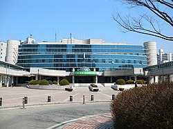
Hanam (Korean: 하남; Korean pronunciation: [ha.nam]) is a city in Gyeonggi Province, South Korea. Formerly a part of Gwangju County, it was designated a city in 1989. The ancient Baekje capital of Hanam Wiryeseong may have been located there.
Hanam
하남시 | |
|---|---|
| Korean transcription(s) | |
| • Hangul | 하남시 |
| • Hanja | 河南市 |
| • Revised Romanization | Hanam-si |
| • McCune–Reischauer | Hanam-si |
 Hanam City Hall | |
 Location in South Korea | |
| Country | |
| Region | Gyeonggi Province (Sudogwon) |
| Administrative divisions | 13 |
| Area | |
• Total | 93.07 km2 (35.93 sq mi) |
| Population (September 2024[1]) | |
• Total | 329,693 |
| • Density | 1,612/km2 (4,180/sq mi) |
| • Dialect | Seoul |
Lying immediately east of Seoul, Hanam is also bordered by Namyangju, Gwangju, and Seongnam.
Administrative divisions
editHanam is divided as follows:
- Cheonhyun-dong (천현동)
- Shinjang1-dong (신장1동)
- Shinjang2-dong (신장2동)
- Deokpung1-dong (덕풍1동)
- Deokpung2-dong (덕풍2동)
- Deokpung3-dong (덕풍3동)
- Pungsan-dong (풍산동)
- Misa1-dong (미사1동)
- Misa2-dong (미사2동)
- Gambuk-dong (감북동)
- Gami-dong (감이동)
- Wyrye-dong (위례동)
- Chungung-dong (춘궁동)
- Choi-dong (초이동)
Statistics
edit| Population (2024): | 329,498 |
| Yearly birth (2018): | 2,039 |
| Yearly death (2018): | 721 |
| Households (2018): | 93,741 |
| Move-in (2017): | 41,988 |
| Move-out (2017): | 25,945 |
Climate
editHanam has a humid continental climate (Köppen: Dwa), but can be considered a borderline humid subtropical climate (Köppen: Cwa) using the −3 °C (27 °F) isotherm.
| Climate data for Hanam (2004–2020 normals) | |||||||||||||
|---|---|---|---|---|---|---|---|---|---|---|---|---|---|
| Month | Jan | Feb | Mar | Apr | May | Jun | Jul | Aug | Sep | Oct | Nov | Dec | Year |
| Mean daily maximum °C (°F) | 2.7 (36.9) |
5.9 (42.6) |
12.1 (53.8) |
18.8 (65.8) |
24.9 (76.8) |
28.7 (83.7) |
29.5 (85.1) |
30.6 (87.1) |
26.2 (79.2) |
21.0 (69.8) |
12.6 (54.7) |
4.1 (39.4) |
18.1 (64.6) |
| Daily mean °C (°F) | −2.4 (27.7) |
0.7 (33.3) |
6.2 (43.2) |
12.4 (54.3) |
18.3 (64.9) |
22.9 (73.2) |
25.1 (77.2) |
26.0 (78.8) |
20.8 (69.4) |
14.2 (57.6) |
7.2 (45.0) |
−0.6 (30.9) |
12.6 (54.7) |
| Mean daily minimum °C (°F) | −6.9 (19.6) |
−4.3 (24.3) |
0.9 (33.6) |
6.6 (43.9) |
12.4 (54.3) |
18.0 (64.4) |
21.9 (71.4) |
22.3 (72.1) |
16.5 (61.7) |
9.2 (48.6) |
2.5 (36.5) |
−5.0 (23.0) |
7.8 (46.0) |
| Average precipitation mm (inches) | 11.6 (0.46) |
18.3 (0.72) |
31.0 (1.22) |
57.2 (2.25) |
66.8 (2.63) |
103.1 (4.06) |
379.1 (14.93) |
230.9 (9.09) |
120.3 (4.74) |
34.5 (1.36) |
42.0 (1.65) |
15.8 (0.62) |
1,110.6 (43.72) |
| Average precipitation days (≥ 0.1 mm) | 3.0 | 3.3 | 5.7 | 7.4 | 6.3 | 7.4 | 13.8 | 12.1 | 6.6 | 3.9 | 6.2 | 4.8 | 80.5 |
| Source: Korea Meteorological Administration[2] | |||||||||||||
Sister cities
editSee also
editReferences
edit- ^ "Population statistics". Korea Ministry of the Interior and Safety. 2024.
- ^ "Climatological Normals of Korea (1991 ~ 2020)" (PDF) (in Korean). Korea Meteorological Administration. Archived from the original (PDF) on 29 January 2022. Retrieved 7 June 2023.
- ^ Yvonne T. Nathan (3 December 2013). "Shah Alam signs pact with South Korean city of Hanam". The Star. Retrieved 21 December 2015.
External links
edit- City government website (in English)
- City Council website Archived 2019-07-22 at the Wayback Machine (in Korean)
37°31′N 127°12′E / 37.517°N 127.200°E

