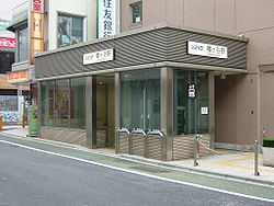
Hatagaya (幡ヶ谷) is an area within Shibuya, Tokyo, Japan.
Hatagaya
幡ヶ谷 | |
|---|---|
 Hatagaya Station | |
 | |
| Country | |
| Prefecture | |
| Special ward | |
| Population (1 October 2020) | |
• Total | 16,782[1] |
| Time zone | UTC+09:00 |
| ZIP code | 151-0072 |
| Telephone area code | 03 |
This article needs additional citations for verification. (January 2016) |


Origins
editIt is said the origin of the name Hatagaya, comes from the year 1082, when Minamoto no Yoshiie was returning to his home and stopped in the area and washed a white flag, put it up on a pole and hosted a banquet. (Hatagaya translates to "flag valley.")[2]
Transportation
editHatagaya is served by Hatagaya Station on the Keio New Line. It is also served by bus, linking Shinjuku, Nakano, Shibuya, Asagaya and Yoyogi.
Economy
editCompanies including Olympus and Terumo have offices here. The main shopping district in Hatagaya is Rokugo Dori (六号通り), a street along which there are many shops, restaurants and bars.[3]
Demography
edit| District | Number of Households |
Total Population |
Male | Female |
|---|---|---|---|---|
| Hatagaya 1-chōme | 2,374 | 3,609 | 1,648 | 1,961 |
| Hatagaya 2-chōme | 4,081 | 6,357 | 2,994 | 3,363 |
| Hatagaya 3-chōme | 3,981 | 6,847 | 3,368 | 3,479 |
| Total | 10,436 | 16,813 | 8,010 | 8,803 |
| Year | Total Population |
|---|---|
| 2012 | 15,335 |
| 2013 | 15,610 |
| 2014 | 15,588 |
| 2015 | 15,875 |
| 2016 | 16,029 |
| 2017 | 16,168 |
| 2018 | 16,479 |
| 2019 | 16,647 |
| 2020 (October 1) | 16,813 |
| Year | Total
Population |
Female
Population |
Male
Population |
Japanese
Population |
Non-Japanese
Population |
|---|---|---|---|---|---|
| 2015 | 15,875 | 8,289 | 7,586 | 15,469 | 406 |
| 2016 | 16,029 | 8,328 | 7,701 | 15,573 | 456 |
| 2017 | 16,168 | 8,423 | 7,745 | 15,707 | 461 |
| 2018 | 16,479 | 8,591 | 7,888 | 15,999 | 480 |
| 2019 | 16,647 | 8,717 | 7,930 | 16,166 | 481 |
| 2020 (October 1) | 16,813 | 8,803 | 8,010 | 16,361 | 452 |
Places of interest
editCultural
editTemples
edit- Seiganji (清岸寺) (Hatagaya 2-36-1)[4]
Schools
editShibuya Board of Education operates public elementary and junior high schools.
Hatagaya 2-chome 35, 38, 43, 45, 49, and 5-56 ban, and Hatagaya 3-chome 1-36 and 38-81 ban are zoned to Nakahata Elementary School (中幡小学校). Hatagaya 1-chome 1-9 and 13-34-ban and 2-chome 1-19, 39-42, 44, 46-48, and 50-ban are zoned to Nishihara Elementary School (西原小学校). Hatagaya 1-chome 10-12 ban, 2-chome 20-34, 36, and 37-ban, and 3-chome 37-ban are zoned to Sasazuka Elementary School (笹塚小学校).[5]
Hatagaya 3-chome, 1-chome 10-12 ban, and 2-chome 20-38, 43, 45, 49, and 51-56 ban are zoned to Sasazuka Junior High School (笹塚中学校). Hatagaya 1-chome 1-9 and 13-34-ban and 2-chome 1-19, 39-42, 44, 46-48, and 50-ban are zoned to Yoyogi Junior High School (代々木中学校).[6]
Schools within Hatagaya:
- Nakahata Elementary School (渋谷区立中幡小学校) (Hatagaya 3-49-1)[7]
Other
edit- Tokyo Fire Department Fire Technology and Safety Laboratory (東京消防庁消防科学研究所) (Hatagaya 1-13-20)[8]
References
edit- ^ a b c d "住民基本台帳・外国人登録による人口". 渋谷区. Shibuya City. Archived from the original on 18 October 2020. Retrieved 21 October 2020.
- ^ 渋谷区史
- ^ "Corporate Profile". Terumo. Retrieved 22 October 2020.
- ^ "Home". Seiganji Temple. Retrieved 27 October 2020.
- ^ "学校別通学区域(小学校)". City of Shibuya. Retrieved 2022-10-08. - Has elementary zoning
- ^ "学校別通学区域(中学校)". City of Shibuya. Retrieved 2022-10-08. - Has junior high school zoning
- ^ "Home". Nakahata Elementary School. Retrieved 27 October 2020.
- ^ "Home". Tokyo Fire Department. Retrieved 27 October 2020.
35°40′41″N 139°40′25″E / 35.6781°N 139.6736°E