Kisantu, is a town in the western Democratic Republic of Congo, lying south west of Kinshasa, on the Inkisi River. It is known for its large cathedral and for its botanical gardens, which include an arboretum of indigenous trees.[1]
Kisantu | |
|---|---|
Town | |
| Ville de Kisantu | |
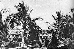
 Catholic Jesuits' mission at Kisantu, circa 1942 | |
Location in the Democratic Republic of the Congo | |
| Coordinates: 05°07′44″S 15°05′05″E / 5.12889°S 15.08472°E | |
| Country | DR Congo |
| Province | Kongo Central |
| Communes | Kisantu, Lukaya District |
| Population (2021) | |
| • Metro | 78,000 |
| Time zone | UTC+1 (CAT) |
| National language | Kituba |
| Climate | Aw |
Location
editKisantu is located in Kongo Central Province, along the eastern bank of the Inkisi River, as it flows northwards to empty into the Congo River. On the western bank of the river, is the settlement called Inkisi. Sometimes the metropolitan area is referred to as Inkisi-Kisantu. This is approximately 231 kilometres (144 mi) northeast of the city of Matadi, the provincial headquarters.[2] Kisantu is located approximately 104 kilometres (65 mi) southwest of the city of Kinshasa, the national capital.[3]
The geographical coordinates of the town are: 05°07'44.0"S, 15°05'05.0"E (Latitude:-5.128889; Longitude:15.084722).[4] The town is located at an average elevation of 404 metres (1,325 ft) above mean sea level.[5]
Overview
editOne of the tourist attractions to he town is the Kisantu Botanical Gardens (French: Jardin Botanique de Kisantu (KISA)). They were established in 1900 by Father Justin Gillet, a Jesuit priest. Between 2004 and 2008, the gardens were rehabilitated with "the support of the European Union and the National Botanic Garden of Belgium".[6]
The botanical gardens occupy an area that measures approximately 225 hectares (560 acres), bordered to the west by the Inkisi River. There are over 12.5 kilometres (8 mi) of roads and pedestrian pathways within the gardens. The gardens attract researchers, botanists, naturalists, school children and ordinary tourists from inside and outside the Democratic Republic of the Congo.[6]
Population
editAs of October 2022, the article in this reference estimated the population of Kisantu Town at approximately 78,000 people.[1]
Transport
editKisantu is served by a station on the national railway system. It also has an airport.[7] A good national road (N1), leads north to Kinshasa and southwest to he port city of Matadi.[8]
Prominent people
editThe legendary DR Congolese saxophonist, composer, bandleader, producer, record label founder, and music-business executive, Verckys Kiamuangana Mateta (19 May 1944 – 13 October 2022), was born in Kisantu.[9]
See also
editReferences
edit- ^ a b Wilderness Explorers Africa (16 October 2022). "Kisantu Town DRC". Wildernessexplorersafrica.com. Kampala, Uganda. Retrieved 16 October 2022.
- ^ "Road Distance Between Matadi, DR Congo And Kisantu, DR Congo" (Map). Google Maps. Retrieved 16 October 2022.
- ^ "Road Distance Between Kinshasa, DR Congo And Kisantu, DR Congo" (Map). Google Maps. Retrieved 16 October 2022.
- ^ "Location of Kisantu, Democratic Republic f the Congo" (Map). Google Maps. Retrieved 16 October 2022.
- ^ Get A Map (16 November 2022). "Elevation of Kisantu Town, DR Congo". Getamap.net. Retrieved 16 October 2022.
- ^ a b "Jardin Botanique de Kisantu (Kisantu Botanical Gardens)" (Translated from the original French language). Global Plants. 16 October 2022. Retrieved 16 October 2022.
- ^ Airport information for FZAS at Great Circle Mapper.
- ^ "Map Showing National Road N1, In DRCongo" (Map). Google Maps. Retrieved 16 October 2022.
- ^ bopili (13 October 2022). "Saxophonist Verckys Kiamuangana bowed out Thursday in Kinshasa" (Translated from the original French language). ACPCongo.com. Kinshasa, DRCongo. Retrieved 16 October 2022.
External links
edit- Khonde Kumbu, R.; Mbanzulu Makola, K.; Bin, Lu (2016). "Prevalence of Schistosoma mansoni Infection in Four Health Areas of Kisantu Health Zone, Democratic Republic of the Congo". Advances in Medicine. 2016: 1–5. doi:10.1155/2016/6596095. PMC 4992513. PMID 27579346.
