Jacinto, founded in 1836, was named after the Battle of San Jacinto in the Texas Revolution.[3][4][5]
Jacinto, Mississippi | |
|---|---|
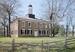
 Jacinto Courthouse. Photo by Jack Boucher, 1975. | |
| Coordinates: 34°45′44″N 88°25′39″W / 34.76222°N 88.42750°W | |
| Country | |
| State | |
| County | Alcorn |
| Area | |
• Total | 0.87 sq mi (2.26 km2) |
| • Land | 0.87 sq mi (2.26 km2) |
| • Water | 0.00 sq mi (0.00 km2) |
| Elevation | 545 ft (166 m) |
| Population (2020) | |
• Total | 52 |
| • Density | 59.56/sq mi (22.99/km2) |
| Time zone | UTC-6 (Central (CST)) |
| • Summer (DST) | UTC-5 (CDT) |
| FIPS code | 28-35340 |
| GNIS feature ID | 2812710[2] |
Jacinto was located in the geographic center of the original Tishomingo County, Mississippi.[6] Within ten years of its founding, Jacinto became a flourishing town with stores, hotels, schools, churches and taverns, serving as the center of government and commerce for the county.[3] It is the site of a courthouse built in 1854 in the federal style as the county courthouse for the original Tishomingo County.[4][6] The courthouse has been refurbished and is listed in the National Register of Historic Places.[3] It is open to visitors.
History
editA skirmish occurred on September 7, 1863 in the vicinity of Jacinto between Confederate and Union Cavalry during the American Civil War.[7]
In 1869, Tishomingo was divided into three counties: Tishomingo, Alcorn and Prentiss.[3] Corinth became the county seat of newly established Alcorn County, Iuka of the reduced Tishomingo County, and Booneville of the new county of Prentiss.[3] When the county seat was moved from Jacinto in 1870, the town's importance declined, and town residents and businesses began moving away.[6]
A post office operated under the name Jacinto from 1840 to 1909.[8]
It was first named as a CDP in the 2020 Census which listed a population of 52.[9]
Demographics
edit| Census | Pop. | Note | %± |
|---|---|---|---|
| 2020 | 52 | — | |
| U.S. Decennial Census[10] 2020[11] | |||
2020 census
edit| Race / Ethnicity (NH = Non-Hispanic) | Pop 2020[11] | % 2020 |
|---|---|---|
| White alone (NH) | 49 | 94.23% |
| Black or African American alone (NH) | 0 | 0.00% |
| Native American or Alaska Native alone (NH) | 1 | 1.92% |
| Asian alone (NH) | 0 | 0.00% |
| Pacific Islander alone (NH) | 0 | 0.00% |
| Some Other Race alone (NH) | 0 | 0.00% |
| Mixed Race or Multi-Racial (NH) | 1 | 1.92% |
| Hispanic or Latino (any race) | 1 | 1.92% |
| Total | 52 | 100.00% |
Gallery
edit-
Western façade of the Old Tishomingo County courthouse in Jacinto, 2014
-
Doctor’s Office on the Old Tishomingo County courthouse square in Jacinto, 2014
References
edit- ^ "2020 U.S. Gazetteer Files". United States Census Bureau. Retrieved July 24, 2022.
- ^ a b U.S. Geological Survey Geographic Names Information System: Jacinto, Mississippi
- ^ a b c d e Luke Dove, "The Courthouse at Jacinto", Capital Area Bar Association Newsletter, April 2011, pp. 14-15.
- ^ a b "Look Around Mississippi - Old Jacinto Courthouse", WBLT.com, January 26, 2007. Accessed May 15, 2024.[dead link]
- ^ Photo taken on March 19, 2010 of Jacinto Marker (Jacinto, Mississippi), flickr.com. Accessed May 15, 2024.
- ^ a b c Photo taken on March 19, 2010 of Old Tishomingo County Courthouse (Jacinto, Mississippi), flickr.com. Accessed May 15, 2024.
- ^ "Original Records of the Civil War". Ohio State University. Retrieved September 7, 2017.
- ^ "Alcorn County". Jim Forte Postal History. Retrieved May 1, 2020.
- ^ "Jacinto CDP, Mississippi". United States Census Bureau. Retrieved March 13, 2022.
- ^ "Decennial Census of Population and Housing by Decades". US Census Bureau.
- ^ a b "P2: Hispanic or Latino, and Not Hispanic or Latino by Race – 2020: DEC Redistricting Data (PL 94-171) – Jacinto CDP, Mississippi". United States Census Bureau.

