This article needs additional citations for verification. (June 2021) |
Jiagedaqi District or Jagdaqi District (Oroqen: Jagdaqi, meaning "area with Pinus sylvestris var. mongolica Litvin"; simplified Chinese: 加格达奇区; traditional Chinese: 加格達奇區; pinyin: Jiāgédáqí Qū) is a district and the de facto seat of Daxing'anling Prefecture, Northeast China. Its physical location is in Oroqen Autonomous Banner, Hulunbuir, Inner Mongolia; however, it is de facto under the jurisdiction of Daxing'anling Prefecture, Heilongjiang Province due to no suitable location of seat in Daxing'anling itself.[citation needed] The government of Inner Mongolia disputes this arrangement.[citation needed]
Jiagedaqi
加格达奇(行政)区 | |
|---|---|
 | |
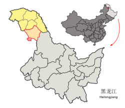
 Location of the district (red outline) in Daxing'anling Prefecture (yellow fill) and Heilongjiang | |
| Coordinates (Jiagedaqi District government): 50°24′31″N 124°08′23″E / 50.4087°N 124.1396°E | |
| Country | China |
| Province | Heilongjiang |
| Prefecture | Daxing'anling |
| District seat | Changhong Subdistrict |
| Area | |
| • Total | 1,587 km2 (613 sq mi) |
| Elevation | 472 m (1,549 ft) |
| Population (2020 census)[1] | |
| • Total | 137,105 |
| • Density | 86/km2 (220/sq mi) |
| Time zone | UTC+8 (China Standard) |
| Postal code | 165000 |
| Area code | 0457 |
| Website | www |
Administrative divisions
editJiagedaqi District is divided into 6 subdistricts and 2 townships:[2]
- Dongshan Subdistrict (东山街道)
- Weidong Subdistrict (卫东街道)
- Hongqi Subdistrict (红旗街道)
- Changhong Subdistrict (长虹街道)
- Shuguang Subdistrict (曙光街道)
- Guangming Subdistrict (光明街道)
- Jiabei Township (加北乡)
- Baihua Township (白桦乡)
Climate
edit| Climate data for Jiagedaqi, elevation 372 m (1,220 ft), (1991–2020 normals, extremes 1981–2010) | |||||||||||||
|---|---|---|---|---|---|---|---|---|---|---|---|---|---|
| Month | Jan | Feb | Mar | Apr | May | Jun | Jul | Aug | Sep | Oct | Nov | Dec | Year |
| Record high °C (°F) | −1.0 (30.2) |
6.4 (43.5) |
19.2 (66.6) |
27.8 (82.0) |
35.2 (95.4) |
39.7 (103.5) |
37.2 (99.0) |
36.1 (97.0) |
31.0 (87.8) |
25.3 (77.5) |
13.1 (55.6) |
0.5 (32.9) |
39.7 (103.5) |
| Mean daily maximum °C (°F) | −14.1 (6.6) |
−8.4 (16.9) |
0.1 (32.2) |
10.7 (51.3) |
19.1 (66.4) |
24.8 (76.6) |
26.5 (79.7) |
24.3 (75.7) |
18.3 (64.9) |
8.4 (47.1) |
−5.3 (22.5) |
−14.3 (6.3) |
7.5 (45.5) |
| Daily mean °C (°F) | −21.9 (−7.4) |
−17.5 (0.5) |
−8.0 (17.6) |
3.4 (38.1) |
11.5 (52.7) |
17.3 (63.1) |
20.0 (68.0) |
17.5 (63.5) |
10.4 (50.7) |
1.1 (34.0) |
−12.2 (10.0) |
−21.0 (−5.8) |
0.1 (32.1) |
| Mean daily minimum °C (°F) | −27.9 (−18.2) |
−24.9 (−12.8) |
−15.5 (4.1) |
−3.9 (25.0) |
3.5 (38.3) |
10.1 (50.2) |
14.4 (57.9) |
12.2 (54.0) |
4.3 (39.7) |
−4.7 (23.5) |
−17.8 (0.0) |
−26.6 (−15.9) |
−6.4 (20.5) |
| Record low °C (°F) | −43.1 (−45.6) |
−42.8 (−45.0) |
−32.3 (−26.1) |
−19.8 (−3.6) |
−9.0 (15.8) |
−5.6 (21.9) |
0.7 (33.3) |
−0.7 (30.7) |
−8.7 (16.3) |
−24.7 (−12.5) |
−37.5 (−35.5) |
−43.7 (−46.7) |
−43.7 (−46.7) |
| Average precipitation mm (inches) | 4.7 (0.19) |
3.6 (0.14) |
6.9 (0.27) |
19.4 (0.76) |
47.1 (1.85) |
91.1 (3.59) |
155.2 (6.11) |
119.0 (4.69) |
65.1 (2.56) |
23.5 (0.93) |
10.3 (0.41) |
7.0 (0.28) |
552.9 (21.78) |
| Average precipitation days (≥ 0.1 mm) | 6.2 | 4.2 | 5.2 | 5.9 | 10.2 | 14.2 | 16.0 | 14.5 | 10.0 | 6.6 | 6.4 | 7.3 | 106.7 |
| Average snowy days | 8.2 | 6.5 | 7.8 | 6.3 | 0.8 | 0.1 | 0 | 0 | 0.3 | 5.3 | 8.4 | 9.9 | 53.6 |
| Average relative humidity (%) | 68 | 64 | 57 | 50 | 52 | 69 | 78 | 80 | 73 | 62 | 69 | 71 | 66 |
| Mean monthly sunshine hours | 179.0 | 210.0 | 259.6 | 247.4 | 252.0 | 249.8 | 230.1 | 222.8 | 213.5 | 198.7 | 171.1 | 156.8 | 2,590.8 |
| Percent possible sunshine | 67 | 73 | 70 | 59 | 52 | 51 | 47 | 50 | 57 | 61 | 64 | 63 | 60 |
| Source: China Meteorological Administration[3][4] | |||||||||||||
Transport
editReferences
edit- ^ "2020年大兴安岭地区第七次全国人口普查主要数据公报" (in Chinese). Government of Daxing'anling Prefecture. 2021-05-31.
- ^ "2022年统计用区划代码:加格达奇区". National Bureau of Statistics.
- ^ 中国气象数据网 – WeatherBk Data (in Simplified Chinese). China Meteorological Administration. Retrieved 5 July 2023.
- ^ 中国气象数据网 (in Simplified Chinese). China Meteorological Administration. Retrieved 5 July 2023.
External links
edit- Official site of Jiagedaqi (in Chinese)

