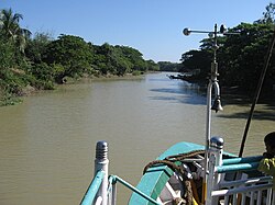
The Kangsha (Bengali: কংস নদী, romanized: kaṁsa nadī) (also known as the Kangsai or the Kangsabati[1]) is a river in the northern parts of Mymensingh[2] and Netrakona[3] districts of Bangladesh. The Someshwari is one of the rivers that join it from the north.
| Kangsha River | |
|---|---|
 View of the Kangsha River from a launch | |
 | |
| Location | |
| Country | Bangladesh |
| Districts | |
| Physical characteristics | |
| Discharge | |
| • location | Surma River |
Course
editAt Gaglajuri, the Dhanu is joined by the Kangsha which flows from the Garo Hills past Nalitabari as the Bhogai is at its best in the Netrakona subdivision at Deotukon and Barhatta. After Mohanganj it becomes a narrow, winding khal with banks little higher than its own lowest level.
The river flows past Barhatta, Mohanganj and Dharampasha upazilas. The Dhala and Dhanu rivers which flow into Kishoreganj District are branches of the Kangsha.[3] The Kangsha flows into Surma River in Sunamganj District.
Watershed
editAccording to a report on wetland protection, "All floodwaters come from the Garo/Meghalaya Hills through a number of hill streams and rivers."[4]
Gallery
edit-
A farmer busy on the banks of the Kangsha River
-
A brick kiln at Dharampasha on the banks of the Kangsha River
-
The bamboo market at Pashukhali
See also
editReferences
edit- ^ Sultana Nasrin Baby (2012). "Kangsa River". In Sirajul Islam and Ahmed A. Jamal (ed.). Banglapedia: National Encyclopedia of Bangladesh (Second ed.). Asiatic Society of Bangladesh.
- ^ "Map of Mymensingh District". Banglapedia. Asiatic Society of Bangladesh. Retrieved 2007-12-02.
- ^ a b "Map of Netrokona District". Banglapedia. Asiatic Society of Bangladesh. Retrieved 2007-12-02.
- ^ Md Liaqat Ali and Paul Thompson. "Wetland Protection and Enhancement through Sanctuaries in Bangladesh: Management of Aquatic Ecosystems through Community Husbandry" (PDF). MACH Technical Paper 4. Winrock International, Bangladesh Center for Advanced Studies, Centre for Natural Resource Studies, Caritas, Bangladesh. Retrieved 13 February 2014.