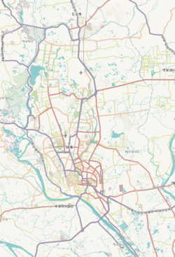
Khilgaon (Bengali: খিলগাঁও) is a thana (police jurisdiction) and neighbourhood in the city of Dhaka, Bangladesh. The thana encompasses Dhaka South City Corporation wards 24, 25, and 26.[5][2] In 2022, it had a population of about 380 thousand.
Khilgaon Thana
খিলগাঁও থানা | |
|---|---|
 Expandable map of vicinity of Khilgaon Thana | |
| Coordinates: 23°45′03″N 90°25′35″E / 23.75083333°N 90.42638889°E | |
| Country | |
| Division | Dhaka Division |
| District | Dhaka District |
| Formed | 1988 |
| Area | |
• Total | 14.83 km2 (5.73 sq mi) |
| Elevation | 23 m (75 ft) |
| Population | |
• Total | 380,740 |
| • Density | 26,000/km2 (66,000/sq mi) |
| Time zone | UTC+6 (BST) |
| Postal code | 1219[3] |
| Area code | 02[4] |
Geography
editKhilgaon is bounded by Badda Thana on the north, Motijheel Thana, Sabujbagh Thana and Demra Thana on the south, Rupganj Upazila on the east and Rampura Thana on the west. Its total area is 14.83 square kilometres (5.73 sq mi).[5]
History
editDuring the 17th century, Khilgaon thrived as a bustling trading hub, situated alongside the now-defunct Pandu river.[6] Few families inhabited this uneven terrain, and agriculture was virtually non-existent. The name Khilgaon originated from Bengali, where khil refers to uncultivated land and gaon means village, reflecting its rural origins. Despite evolving into a significant settlement within the megacity, the name has endured. Later on, a prominent Chowdhury family acquired extensive landholdings and established their residence here, lending its name to the Chowdhury Para locality.[7]
In 1988, Khilgaon Thana was formed comprising parts of Sabujbagh, Gulshan and Demra thanas.[5]
Demographics
editAt the 2022 Bangladeshi census, Khilgaon Thana had a population of 380,740 with average household size of 3.81 members, and an average literacy rate of 85.33 percent, more than ten percent higher than the national average.[2]
Points of interest
editIn the mid-2010s, the 1.85-kilometer Shaheed Baki Road and 300-meter Chowdhury Para Road gained prominence as a renowned food street. Established in 1986, the Taltola City Corporation Super Market occupies a sprawling 4.45-acre area, housing a total of 858 shops, and has become a favoured shopping destination.[10] Additionally, Khilgaon Thana hosts the headquarters of the Bangladesh Ansar.[5]
Transportation
editRickshaws, CNGs are always available. There are also some buses available which includes Midline, Bahon, Turag, Noor-E-Mekkah, Raida, Labbaik, Talukdar etc. These buses link between Khilgaon, Farmgate, Nilkhet, Motijheel, Dhanmondi, Mohammadpur, Badda, Gulshan, Mirpur, Moghbazar and many other places.[citation needed]
The 1.9-kilometre (1.2 mi) Khilgaon Flyover, built in 2005 with the aim of easing traffic congestion, is located in this area.[11]
See also
editReferences
edit- ^ "Geographic coordinates of Dhaka, Bangladesh". DATEANDTIME.INFO. Retrieved 7 July 2016.
- ^ a b c National Report (PDF). Population and Housing Census 2022. Vol. 1. Dhaka: Bangladesh Bureau of Statistics. November 2023. p. 386. ISBN 978-9844752016.
- ^ "Bangladesh Postal Code" (PDF). Bangladesh. 19 October 2024.
- ^ "Bangladesh Area Code". China: Chahaoba.com. 18 October 2024.
- ^ a b c d Molla, Md Tuhin (2012). "Khilgaon Thana". In Islam, Sirajul; Jamal, Ahmed A. (eds.). Banglapedia: National Encyclopedia of Bangladesh (Second ed.). Asiatic Society of Bangladesh.
- ^ Hasan, Faruque (August 2008). "From Jahangirnagar to Dhaka". Forum. Vol. 3, no. 8. Retrieved 6 May 2024.
- ^ Hossain, Nazir (April 1995). Kiṃbadantira Ḍhākā কিংবদন্তির ঢাকা [Dhaka in Legends] (in Bengali) (3rd ed.). Dhaka: Three Star Cooperative Multipurpose Society Limited. pp. 180–181. LCCN 95905768. OCLC 33970022.
- ^ "Bangladesh Population and Housing Census 2011 Zila Report – Dhaka" (PDF). bbs.gov.bd. Bangladesh Bureau of Statistics.
- ^ "Community Tables: Dhaka district" (PDF). bbs.gov.bd. 2011.
- ^ Rahman, Sadiqur (18 September 2023). "How a food street transformed the face of Khilgaon-Taltola". The Business Standard. Retrieved 6 May 2024.
- ^ "Much-awaited Khilgaon fly-over to be opened Wednesday". bdnews24.com. 21 March 2005. Retrieved 10 April 2024.


