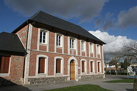
La Remuée (French pronunciation: [la ʁəmɥe]) is a commune in the Seine-Maritime department in the Normandy region in northern France.
La Remuée | |
|---|---|
 The town hall in La Remuée | |
| Coordinates: 49°31′43″N 0°24′15″E / 49.5286°N 0.4042°E | |
| Country | France |
| Region | Normandy |
| Department | Seine-Maritime |
| Arrondissement | Le Havre |
| Canton | Saint-Romain-de-Colbosc |
| Intercommunality | Le Havre Seine Métropole |
| Government | |
| • Mayor (2020–2026) | Nadège Courche[1] |
| Area 1 | 7.03 km2 (2.71 sq mi) |
| Population (2021)[2] | 1,285 |
| • Density | 180/km2 (470/sq mi) |
| Time zone | UTC+01:00 (CET) |
| • Summer (DST) | UTC+02:00 (CEST) |
| INSEE/Postal code | 76522 /76430 |
| Elevation | 103–135 m (338–443 ft) (avg. 129 m or 423 ft) |
| 1 French Land Register data, which excludes lakes, ponds, glaciers > 1 km2 (0.386 sq mi or 247 acres) and river estuaries. | |
Geography
editA farming village in the Pays de Caux, some 10 miles (16 km) east of Le Havre, at the junction of the D112 and D81 roads.
Heraldry
edit| The arms of La Remuée are blazoned : Gules, 2 swords in saltire argent between 4 martlets Or.
|
Population
edit| Year | Pop. | ±% p.a. |
|---|---|---|
| 1968 | 484 | — |
| 1975 | 640 | +4.07% |
| 1982 | 711 | +1.51% |
| 1990 | 861 | +2.42% |
| 1999 | 1,176 | +3.52% |
| 2007 | 1,335 | +1.60% |
| 2012 | 1,320 | −0.23% |
| 2017 | 1,284 | −0.55% |
| Source: INSEE[3] | ||
Places of interest
edit- The church of St. Thomas, dating from the nineteenth century.
- Notre-Dame church, dating from the thirteenth century.
- The chateau de Marefosse.
See also
editReferences
edit- ^ Liste des maires du département de la Seine-Maritime, 10 August 2020
- ^ "Populations légales 2021" (in French). The National Institute of Statistics and Economic Studies. 28 December 2023.
- ^ Population en historique depuis 1968, INSEE
External links
editWikimedia Commons has media related to La Remuée.
- Official website of the commune (in French)
- Printemps de La Remuée road run, the premier race in the département[permanent dead link] (in French)


