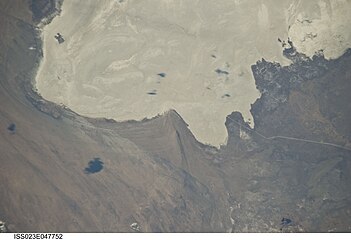
The Torey Lakes are a pair of soda lakes, Barun-Torey and Zun-Torey, in Russia's Zabaykalsky Krai, on the border with Mongolia — the Mongolia–Russia border runs across the southern tip of Zun-Torey lake.[4][5][6]
| Torey Lakes | |
|---|---|
.JPG) Lake Zun-Torey | |
 Torey Lakes Location of the Torey Lakes | |
| Coordinates | 50°04′N 115°31′E / 50.067°N 115.517°E |
| Type | endorheic soda lakes |
| Primary inflows | Ulz River (Uldza), Imalka River |
| Catchment area | 26,000 km2 (10,000 sq mi) |
| Basin countries | Russia, Mongolia |
| Designation | Ramsar Site (1994), Biosphere Reserve (1997), World Heritage Site (2017),[1] International Protected Area, Strictly Protected Area, Important Crane Area (1997), Anatidae Network Site (1999)[2][3] |
| Surface elevation | 595 m (1,952 ft) |
Geography and hydrography
editThe two lakes are the remains of a large lake or sea whose surface, according to Shamsutdinov (1983), once reached 2,400 km2 (930 sq mi)[7] some 700,000 years ago.[8] They are the largest soda lakes in the arid zone[9][a] in the trans-Baikal region.[2] They lie close to one another,[5][6] connected by the Utochi channel,[7] in a closed basin with no outlet to the sea.
The size and volume of water in the lakes varies greatly with the region's multi-decadal rainfall and climate cycles. These interdecadal cycles last from 27 years to 35 years; they depend on variations in atmospheric moistening: relatively moist and very cold periods alternate with dry and relatively warm periods.[10] For example, Barun-Torey lake completely dried up in summer 2009, and started refilling in 2013; Zun-Torey lake dried up in autumn 2017.[11] The dry bed of Barun-Torey lake is strewn with temporary freshwater pools fed by groundwater and precipitations,[12] even though that groundwater is not necessarily freshwater.[13][b] These pools are alkaline, with a pH around 8.2 – 9.0; they are oligohaline (0.5–1.0 g × l-1), rather warm (26 to 30°С), most are muddy (TR = 0.1–0.3 m). Those at the western shore of the lake are fed by groundwater discharge through a geological fracture.[12]
In periods of high water level, Barun-Torey lake and Zun-Torey lake have the same hydrochemical parameters: oligohaline and alkaline.[14]
-
 Satellite view: Zun-Torey lake on the right (east), Barun-Torey lake on the left (west). April 2003
 -
 Zun-Torey lake on the right (east), Barun-Torey lake on the left (west). May 2010


Barun-Torey
editDuring high-water years, Barun-Torey lake has an area of 550 km2 (210 sq mi), with a volume of 1.4 km3 (0.34 cu mi); the average depth is 2.5 m, with a maximum depth of 4.3 m. In low-water years, the lake shrinks dramatically and can dry up completely.[15] The southern end of the lake extends into Mongolia.[5][6]
Barun-Torey lake is fed by two rivers. The Ulz River (Uldza River or Ulz Gol) flows into the lake from the south and forms a large estuary. The Imalka River flows into the lake from the west.[15]
When the water level reaches 596.1 m in elevation, Barun-Torey water starts running off into Zun-Torey lake via the Utochi channel. Once the surfaces of the two lakes are levelled up, the wind and other factors induce changes in the direction of the current in the channel. When the water level falls, the shallower Barun-Torey lake dries up quicker and the water in the Utochi channel flows from Zun-Torey lake to Barun-Torey lake.[7] As the lake level falls and during the initial refilling of the lake, three stages of changes in the planktonic associations have been identified; the plankton communities increase in species richness and abundance in the transient pools.[11]
- Barun-Torey lake
-
 Northern end of the dried-up lake. January 2010
 -
 Southern shore of the lake, in Mongolia. May 2010


Zun-Torey
editLake Zun-Torey lies east of Lake Barun-Torey. During high water, the lake has a surface area of 285 km2 and a volume of 1.6 km3; but in 1999 its surface reached 301.6 km2 and in 2015 it reached 254 km2. The average depth is 4.5 m, and the maximum depth (in the northern part of the lake, where the lake bed drops steeply from the shore) is 6.7 m; its length is 23 km and its width is 13 km. The lake is round and has a single island, which turns into a peninsula when the water level is low. Lake Zun-Torey is mostly fed by the channel from Lake Baran-Torey, and does not dry as extensively or vary in extent as much as Lake Baran-Torey does.[16]
During the aridification of Zun-Torey lake, four stages of changes in the planktonic associations were identified; the phytoplankton decreased in abundance and biomass, and was dominated by green algae and diatoms; the number of zooplankton species decreased but zooplankton's total abundance and biomass increased as the number of individuals increased in some crustacean species.[11]
- Zun-Torey lake
-
 North coast. June 28, 2010
 -
 East point of the lake. April 2009
.JPG)

Ecology
editThe lakes and their environs are home to 305 bird species (including 90 breeding species), 42 species of mammals, various reptile, amphibian, and fish species, and over 590 insect species.[2]
The lakes and surrounding wetlands are an important breeding, feeding and staging area for many species of migratory waterbirds, including several rare and threatened species.[2] The lakes support significant breeding populations of several threatened bird species, including the red-crowned crane (Grus japonensis), white-naped crane (Grus vipio), swan goose (Anser cygnoides), great bustard (Otis tarda), and relict gull (Ichthyaetus relictus). The lakes are located on East Asian–Australasian Flyway, and millions of birds pass through the Torey Lakes and nearby wetlands in spring and autumn. The lakes provide migratory habitat for the critically endangered Siberian crane (Grus leucogeranus) and threatened hooded crane (Grus monacha).[17]
Traditional agriculture, fishing, and animal husbandry are important to the local population.[2]
Protected areas
editAn area of 172,500 ha (426,000 acres), including both lakes and adjacent wetlands and uplands, was designated a Ramsar Site on September 13, 1994.[2] The RAMSAR site comprises 65% lakes, 22% terrestrial steppe ecosystems, 7% river, 5% arable land, and 1% human settlements and roads; its altitude goes from 591 m to 769 m.[8]
The Daursky Nature Reserve or Zapovednik-Daursky state biosphere reserve was designated a UNESCO Biosphere Reserve in 1997, and covers an area of 2,277 km2 (879 sq mi).[18][c] It is also part of the 2017 World Heritage Site "Landscapes of Dauria".[1]
Threat
editA 2020 satellite imagery showed Mongolian plans to build a dam on the Uldza River which would potentially disrupt the natural water cycle and harm the fine balance in the ecosystem. UNESCO World Heritage Committee has expressed its concern on the unannounced construction.[20]
Notes
edit- ^ There are many small soda lakes in the surroundings. Afonina & Tashlikova 2020 map some of them: see "Location map of soda lakes in the Uldz Gol-Torey Basin (Transbaikalia, Russia)".
- ^ In the area that lies beyond the Torey lakes catchment area, there are groundwaters of the Ca-Mg-HCO3, Mg-Ca-HCO3, Mg-Na-HCO3 types, with a pH of 7,4 – 8,3 and salinity up to 1 g/L. Nearer the lakes, Na-HCO3, Na-Mg-HCO3 types of water become predominant and the pH increases from 8 to 8,8. In the lakes' catchment area, groundwater has a higher pH (8.2 – 8.8) and salinity (0.5 – 3.3 g/L). As total dissolved solids (TDS) exceed 2 g/L, Cl- becomes present in significant amounts; and as TDS reach over 3 g/L, SO42- becomes the main anion.[13]
- ^ The Daursky State Nature Biosphere Reserve (SNBR), together with the Chinese and Mongolian reserves, form an international Protected Area named « Dauria ».[19]
References
edit- ^ a b "Landscapes of Dauria". whc.unesco.org. Retrieved 2024-08-24. See also in the "Documents" tab the 2017 map of "Landscapes of Dauria" World Heritage Site (first map of the PDF).
- ^ a b c d e f "Torey Lakes". rsis.ramsar.org. Ramsar Sites Information Service. Retrieved 2024-08-24.
- ^ "Importance of Torey Lakes for Swan Goose". jawgp.org. Japanese Association for Wild Geese Protection. Retrieved 2024-08-24.
- ^ "Топографска карта M-50, G; M 1:1 000 000 - Topographic USSR Chart (in Russian)". Retrieved 24 May 2023.
- ^ a b c "Torey Lakes". openstreetmap.org (map).
- ^ a b c "Torey Lakes". google.fr/maps (satellite view).
- ^ a b c Afonina & Tashlikova 2021, p. 43.
- ^ a b "Torey Lakes" (PDF). rsis.ramsar.org (19. Information Sheet on Ramsar Wetlands). Retrieved 2024-08-24.
- ^ Afonina, Ekaterina Yu; Tashlikova, Natalya A. (March 2023). "An analysis of interannual data on phytoplankton and zooplankton associations in fluctuating soda lakes". Limnologica. 99: 126047. doi:10.1016/j.limno.2022.126047.
- ^ Afonina & Tashlikova 2018, p. 307.
- ^ a b c Afonina, Ekaterina Yu; Tashlikova, Natalya A. (March 2023). "Phytoplankton and zooplankton succession during the dry–refilling cycle: A case study in large, fluctuating soda lakes". Freshwater Biology. 68 (6): 987–1006. doi:10.1111/fwb.14080.
- ^ a b Afonina & Tashlikova 2021, p. 47.
- ^ a b Drebot 2020.
- ^ Afonina & Tashlikova 2021.
- ^ a b Afonina & Tashlikova 2018, p. 308.
- ^ Afonina & Tashlikova 2021, p. 45.
- ^ Simonov, Eugene; Goroshko, Oleg; Tkachuk, Tatiana (2018). "Daurian Steppe Wetlands of the Amur-Heilong River Basin (Russia, China, and Mongolia)". In Finlayson, C.; Milton, G.; Prentice, R.; Davidson, N. (eds.). The Wetland Book. Dordrecht: Springer. doi:10.1007/978-94-007-4001-3_170.
- ^ "Daursky". protectedplanet.net. Protected Planet. Retrieved 2024-08-24.
- ^ Afonina & Tashlykova 2021, p. 43.
- ^ "Planned Mongolian HPP to cause environmental catastrophe at one of planet's oldest lakes". IANS. 30 Nov 2022. Retrieved 1 December 2022.
Bibliography
edit- Afonina, Ekaterina Yu; Tashlikova, Natalya A. (2018). "Planktonic Communities in the Torey Lakes (Zabaikalsky Krai) in a Low Water Year". Journal of Siberian Federal University. Biology. 11: 306–320. doi:10.17516/1997-1389-0074. Retrieved 2024-08-24.
- Afonina, Ekaterina Yu; Tashlikova, Natalya A. (May 2020). "Fluctuations in plankton community structure of endorheic soda lakes of southeastern Transbaikalia (Russia)". Hydrobiologia. 847: 1383–1398. doi:10.1007/s10750-020-04207-z.
- Afonina, Ekaterina Yu; Tashlikova, Natalya A. (February 2021). "Torey lakes, Daursky state Nature Biosphere Reserve, Russia: long-term changes in environmental parameters" (PDF). Nature Conservation Research. 6 (2): 42–52. doi:10.24189/ncr.2021.024.
- Drebot, V. European Association of Geoscientists & Engineers (ed.). "Geochemistry of Soda-Type Groundwater in the Torey Lakes Region (Russia): Differences between Catchment Area and Beyond". EarthDoc (26th European Meeting of Environmental and Engineering Geophysics, held at Near Surface Geoscience, December 7-8, 2020). 2020: 1–5. doi:10.3997/2214-4609.202020025. Retrieved 2024-08-24.
External links
edit Media related to Torey Lakes at Wikimedia Commons