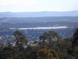
The Bill Gunn Dam is an earth-fill embankment dam with an un-gated spillway located off-stream in Laidley Heights in the South East region of Queensland, Australia. The main purpose of the dam is for irrigation of the Lockyer Valley.[2][3] The resultant reservoir is called Lake Dyer.
| Bill Gunn Dam | |
|---|---|
 View from Cunninghams Crest Lookout | |
Location of the Bill Gunn Dam in Queensland | |
| Country | Australia |
| Location | South East Queensland |
| Coordinates | 27°37′40″S 152°22′37″E / 27.62778°S 152.37694°E |
| Purpose | Irrigation |
| Status | Operational |
| Opening date | 1987 |
| Operator(s) | SEQ Water |
| Dam and spillways | |
| Type of dam | Embankment dam |
| Impounds | Off-stream |
| Height | 18 m (59 ft) |
| Length | 1,160 m (3,810 ft) |
| Dam volume | 722×103 m3 (25.5×10⁶ cu ft) |
| Spillway type | Uncontrolled |
| Spillway capacity | 5 m3/s (180 cu ft/s) |
| Reservoir | |
| Creates | Lake Dyer |
| Total capacity | 6,940 ML (1,530×106 imp gal; 1,830×106 US gal)[1] |
| Catchment area | 3 km2 (1.2 sq mi) |
| Surface area | 100 ha (250 acres) |
| Maximum length | 1,100 m (3,600 ft) |
| Maximum width | 600 m (2,000 ft) |
| Maximum water depth | 10.7 m (35 ft) |
| Normal elevation | 110 m (360 ft) AHD |
| Website www.seqwater.com.au | |
Location and features
editLocated 1.5 kilometres (0.93 mi) west of the town of Laidley, the dam was developed to increase the capacity of the existing Lake Dyer, a natural lake adjacent to Laidley Creek, a tributary of Lockyer Creek. The dam was named after the Queensland politician Bill Gunn and is managed by SEQ Water.[2]
The 1,170 m (3,840 ft) long earthfill structure has a maximum height of 12 m (39 ft) and an overflow spillway which diverts excess water into Laidley Creek. The dam has a storage capacity of 6,950 megalitres (1,530×106 imp gal; 1,840×106 US gal) and a maximum surface area of 108 hectares (270 acres).
Water from the dam is used for irrigation, in the densely cropped Lockyer Valley.[2] Bill Gunn Dam suffers from high drawdowns and summer evaporation which together with phosphate fertilizer creates significant blue green algae problems.[2] In November 2005, during drought conditions in the area, the dam's water level declined to just 1%.[4]
Recreation
editA boating permit is not required, however a maximum of eight boats are allowed on the lake at once.[2] A single concrete boat ramp and some facilities for visitors, including campers, are available at a lakeside caravan park which is managed by the local council.
The dam is stocked with silver perch and golden perch, while bony bream, spangled perch and eel-tailed catfish breed naturally.[2] A Stocked Impoundment Permit is required to fish in the dam.[5] The poor water quality means that fish caught in the dam may, at times of an algae outbreak, be a health hazard if eaten.[2]
See also
editReferences
edit- ^ "Bill Gunn Dam". Water supply: Dams and weirs. Seqwater. 2014. Archived from the original on 26 August 2014. Retrieved 26 June 2014.
- ^ a b c d e f g Harrison, Rod; James, Ernie; Sully, Chris; Classon, Bill; Eckermann, Joy (2008). Queensland Dams. Bayswater, Victoria: Australian Fishing Network. p. 94. ISBN 978-1-86513-134-4.
- ^ "Register of Large Dams in Australia" (Excel (requires download)). Dams information. Australian National Committee on Large Dams. 2010. Archived from the original on 12 December 2013. Retrieved 23 June 2014.
- ^ Rebecca Dull (29 November 2005). "Falls make small impact on dam levels". Ipswich Queensland Times. APN News & Media. Archived from the original on 10 August 2011. Retrieved 28 April 2008.
- ^ Fishing in Queensland dams? You may need a permit. Archived 29 August 2007 at the Wayback Machine
