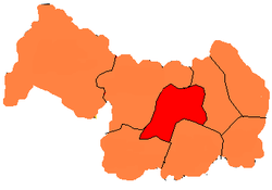
Legnica County (Polish: powiat legnicki) is a unit of territorial administration and local government (powiat) in Lower Silesian Voivodeship, south-western Poland. It came into being on January 1, 1999, as a result of the Polish local government reforms passed in 1998. The county covers an area of 744.6 square kilometres (287.5 sq mi). Its administrative seat is the city of Legnica, although this city is not part of the county (it forms a separate city county, which is an enclave within Legnica County). The only towns in Legnica County are Chojnów and Prochowice.
Legnica County
Powiat legnicki Liegnitz Kreis (German) | |
|---|---|
 Location within the voivodeship | |
 Division into gminas (the red portion is the city of Legnica) | |
| Country | |
| Voivodeship | Lower Silesian |
| Seat | Legnica |
| Gminas | |
| Area | |
• Total | 744.6 km2 (287.5 sq mi) |
| Population (2019-06-30[1]) | |
• Total | 55,318 |
| • Density | 74/km2 (190/sq mi) |
| • Urban | 16,957 |
| • Rural | 38,361 |
| Car plates | DLE |
| Website | http://www.powiat-legnicki.eu |
As at 2019 the total population of the county is 55,318, out of which the population of Chojnów is 13,355, the population of Prochowice is 3,602, and the rural population is 38,361. The majority of the population is polish but there is a small German minority at 0.02% of the population mostly in Koiszków (Koischkau).
Neighbouring counties
editApart from the city of Legnica, Legnica County is also bordered by Polkowice County and Lubin County to the north, Wołów County and Środa Śląska County to the east, Jawor County to the south, and Złotoryja County and Bolesławiec County to the west.
Administrative division
editThe county is subdivided into eight gminas (one urban, one urban-rural and six rural). These are listed in the following table, in descending order of population.
| Gmina | Type | Area (km2) |
Population (2019) |
Seat |
| Chojnów | urban | 5.3 | 13,355 | |
| Gmina Chojnów | rural | 231.2 | 9,634 | Chojnów* |
| Gmina Prochowice | urban-rural | 102.6 | 7,450 | Prochowice |
| Gmina Kunice | rural | 92.8 | 6,960 | Kunice |
| Gmina Miłkowice | rural | 86.4 | 6,721 | Miłkowice |
| Gmina Legnickie Pole | rural | 85.4 | 5,233 | Legnickie Pole |
| Gmina Krotoszyce | rural | 67.6 | 3,326 | Krotoszyce |
| Gmina Ruja | rural | 73.4 | 2,639 | Ruja |
| * seat not part of the gmina | ||||
References
edit- ^ "Population. Size and structure and vital statistics in Poland by territorial division in 2019. As of 30th June". stat.gov.pl. Statistics Poland. 2019-10-15. Retrieved 2020-02-14.

