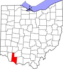
[ 3] Name on the Register[ 4]
Image
Date listed[ 5]
Location
City or town
Description
1
Aberdeen Mound Aberdeen Mound July 15, 1974 (#74001401 ) Western side of State Route 41 , north of Aberdeen[ 6] : 20 38°40′04″N 83°45′47″W / 38.667778°N 83.763056°W / 38.667778; -83.763056 (Aberdeen Mound ) Huntington Township
2
Bailey-Thompson House Bailey-Thompson House November 7, 1976 (#76001373 ) 112 N. Water St. 38°52′00″N 83°54′05″W / 38.866667°N 83.901389°W / 38.866667; -83.901389 (Bailey-Thompson House ) Georgetown
3
Dr. Philip Buckner House and Barn Dr. Philip Buckner House and Barn March 30, 1978 (#78002010 ) 610 S. Main St. 38°51′39″N 83°54′18″W / 38.860833°N 83.905°W / 38.860833; -83.905 (Dr. Philip Buckner House and Barn ) Georgetown
4
Burgett House and Barn Burgett House and Barn November 14, 1978 (#78002013 ) West of Ripley on White Rd. 38°46′41″N 83°53′44″W / 38.778056°N 83.895556°W / 38.778056; -83.895556 (Burgett House and Barn ) Union Township
5
Eagle Creek Covered Bridge Eagle Creek Covered Bridge December 6, 1975 (#75001324 ) 3 mi (4.8 km) south of Decatur on State Route 763 38°40′24″N 83°44′57″W / 38.673333°N 83.749167°W / 38.673333; -83.749167 (Eagle Creek Covered Bridge ) Byrd Township Washed away in 1997[ 7]
6
Eagle Township Works I Mound Eagle Township Works I Mound September 10, 1971 (#71000630 ) 0.5 miles (0.80 km) north of the junction of Fincastle and Mound Rds., east of Fincastle[ 6] : 19 38°59′15″N 83°41′47″W / 38.987500°N 83.696389°W / 38.987500; -83.696389 (Eagle Township Works I Mound ) Eagle Township Near Fincastle
7
Farmers Branch, State Bank of Ohio Farmers Branch, State Bank of Ohio April 21, 1983 (#83001946 ) 14 Front St. 38°44′44″N 83°50′48″W / 38.745556°N 83.846667°W / 38.745556; -83.846667 (Farmers Branch, State Bank of Ohio ) Ripley
8
Georgetown Historic District Georgetown Historic District May 23, 1978 (#78002011 ) Roughly bounded by Water Alley, Pleasant, Short, and State Sts. 38°51′58″N 83°54′15″W / 38.866043°N 83.904068°W / 38.866043; -83.904068 (Georgetown Historic District ) Georgetown
9
Georgetown Public School Georgetown Public School January 25, 1991 (#90002215 ) 307 W. Grant Ave. 38°51′56″N 83°54′26″W / 38.865556°N 83.907222°W / 38.865556; -83.907222 (Georgetown Public School ) Georgetown
10
Ulysses S. Grant Boyhood Home Ulysses S. Grant Boyhood Home October 8, 1976 (#76001374 ) 219 E. Grant Ave. 38°51′57″N 83°54′33″W / 38.865972°N 83.909144°W / 38.865972; -83.909144 (Ulysses S. Grant Boyhood Home ) Georgetown
11
Higginsport School Higginsport School January 14, 2000 (#99001685 ) Junction of Jackson and Gaines Sts. 38°47′27″N 83°58′06″W / 38.790833°N 83.968333°W / 38.790833; -83.968333 (Higginsport School ) Higginsport
12
Henry Martin Farm Henry Martin Farm August 15, 1975 (#75001326 ) 2 mi (3.2 km) north of Ripley on U.S. Route 68 38°46′43″N 83°51′24″W / 38.778611°N 83.856667°W / 38.778611; -83.856667 (Henry Martin Farm ) Union Township
13
Maysville-Aberdeen Bridge Maysville-Aberdeen Bridge June 30, 1983 (#83002823 ) Spans the Ohio River between Aberdeen and Maysville, Kentucky 38°39′19″N 83°45′27″W / 38.655278°N 83.7575°W / 38.655278; -83.7575 (Maysville-Aberdeen Bridge ) Aberdeen Extends into Mason County, Kentucky
14
Mount Orab Station Mount Orab Station October 14, 1975 (#75001325 ) N. Mill and Front Sts. 39°01′46″N 83°55′01″W / 39.029444°N 83.916944°W / 39.029444; -83.916944 (Mount Orab Station ) Mount Orab
15
Daniel Murphy Log House Daniel Murphy Log House June 17, 1982 (#82003548 ) Anderson State Rd., southwest of St. Martin 39°12′19″N 83°54′24″W / 39.205278°N 83.906667°W / 39.205278; -83.906667 (Daniel Murphy Log House ) Perry Township
16
John P. Parker House John P. Parker House January 7, 1980 (#80002944 ) 300 Front St. 38°45′00″N 83°50′58″W / 38.750000°N 83.849556°W / 38.750000; -83.849556 (John P. Parker House ) Ripley Designated a National Historic Landmark in 1997
17
Pisgah Christian Church Pisgah Christian Church November 21, 1980 (#80002945 ) Northwest of Ripley on Pisgah Ridge Rd. 38°46′57″N 83°52′48″W / 38.7825°N 83.88°W / 38.7825; -83.88 (Pisgah Christian Church ) Union Township
18
John Rankin House John Rankin House November 10, 1970 (#70000485 ) East of downtown Ripley on Liberty Hill 38°45′02″N 83°50′36″W / 38.750556°N 83.843333°W / 38.750556; -83.843333 (John Rankin House ) Ripley
19
Red Oak Presbyterian Church Red Oak Presbyterian Church June 17, 1982 (#82003547 ) Cemetery Rd., north of Ripley 38°47′44″N 83°47′44″W / 38.795556°N 83.795556°W / 38.795556; -83.795556 (Red Oak Presbyterian Church ) Union Township
20
Ripley Historic District Ripley Historic District March 7, 1985 (#85000552 ) Roughly bounded by Main, Front, 2nd, 3rd and 4th Sts. 38°44′45″N 83°50′41″W / 38.74585°N 83.844652°W / 38.74585; -83.844652 (Ripley Historic District ) Ripley
21
Stonehurst Stonehurst October 10, 1975 (#75001327 ) 2 mi (3.2 km) north of Ripley off U.S. Route 68 38°46′56″N 83°51′22″W / 38.782222°N 83.856111°W / 38.782222; -83.856111 (Stonehurst ) Union Township
22
Sutton House Sutton House March 25, 1977 (#77001043 ) 0.3 mi (0.48 km) east of Decatur on State Route 125 38°48′49″N 83°41′54″W / 38.813611°N 83.698333°W / 38.813611; -83.698333 (Sutton House ) Byrd Township Destroyed
23
Thompson Farm Thompson Farm January 1, 1976 (#76001375 ) West of Georgetown off State Route 221 38°51′58″N 83°55′23″W / 38.866111°N 83.923056°W / 38.866111; -83.923056 (Thompson Farm ) Pleasant Township
24
Thompson-Bullock House Thompson-Bullock House February 23, 1978 (#78002012 ) West of Georgetown off State Route 221 38°51′59″N 83°55′23″W / 38.866389°N 83.923056°W / 38.866389; -83.923056 (Thompson-Bullock House ) Pleasant Township
25
Thumann Log House Thumann Log House March 27, 1975 (#75001328 ) 1 mi (1.6 km) south of St. Martin at the junction of U.S. Route 50 and State Route 251 39°11′28″N 83°53′51″W / 39.191111°N 83.897500°W / 39.191111; -83.897500 (Thumann Log House ) Perry Township
26
Ursuline Center Ursuline Center June 29, 1976 (#76001372 ) Northeast of Fayetteville off State Route 251 39°12′35″N 83°53′15″W / 39.209722°N 83.8875°W / 39.209722; -83.8875 (Ursuline Center ) Perry Township
