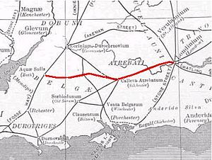
Roman road from Silchester to Bath
The Roman road from Silchester to Bath connected Calleva Atrebatum (Silchester) with Aquae Sulis (Bath) via Spinae (Speen), Cunetio (near Marlborough) and Verlucio (near Sandy Lane).[1] The road was a significant route for east–west travel and military logistics in south-east England during the 1st to 5th centuries.

Parts of its route were subsequently followed by earthworks that are presumed to form part of Wansdyke.[2] During the Middle Ages, the road was used by drovers, as well as by merchants and travellers.
Margary numbered the road as 53.[3] Portions of the Roman road are extant, while in other places all apparent vestiges are absent from view. In the early 19th century, Colt-Hoare surveyed and mapped its course from Overton Down (west of Marlborough) to Bath; the rest was only known in isolated sections until a study by Hugh Toller was published in 2013.[4]
See also
editReferences
edit- ^ Linford, N T; Linford, P K; Payne, A W (February 2018). "Verlucio and Environs Project, Bowood Estate, Calne Without, Wiltshire: Report on Geophysical Surveys". Historic England. Retrieved 5 August 2018.
- ^ Wansdyke Project description of the Roman road from London to Bath
- ^ Margary, Ivan D. (1955). Roman Roads in Britain, Vol. 1. London: Phoenix House. pp. 124–126 – via Internet Archive.
- ^ Toller, Hugh (2013). "The Roman road between Wickham (Speen), Berkshire and Fyfield, Wiltshire (Margary 53)". Wiltshire Archaeological and Natural History Magazine. 106: 52–65 – via Biodiversity Heritage Library.
External links
edit- The road superimposed on a Google Map – saxonhistory.co.uk
51°21′32″N 1°01′54″W / 51.359°N 1.0318°W