Los Nevados National Natural Park (Spanish: Parque Nacional Natural Los Nevados) is a national park located in the Cordillera Central of the Colombian Andes. The park features Colombia's highest and northernmost active volcanoes including the glacier-capped Nevado del Ruiz, Nevado del Tolima, and Nevado de Santa Isabel, and the glacier-free superpáramo peaks (paramillos) of Cisne, Santa Rosa and Quindío. Other elevated structures of volcanic origin within the park are Alto La Piraña, La Olleta, Cerro España, and the Peñas de Caracoli. Cerro Bravo and Cerro Machín are located outside the park but part of the same volcanic region.
| Los Nevados National Natural Park | |
|---|---|
| Parque Nacional Natural Los Nevados | |
 Aerial view of Los Nevados National Park | |
 | |
| Location | Caldas, Risaralda, Quindío and Tolima, Colombia |
| Nearest city | Armenia - Ibagué - Manizales - Pereira |
| Coordinates | 4°48′00″N 75°22′00″W / 4.8°N 75.366667°W |
| Area | 58,300 hectares (225 sq mi) |
| Established | 1973 |
| Visitors | 39,904 (in 2016) |
| Governing body | SINAP |
| Website | |
The park is located in the departments of Caldas, Quindío, Risaralda, Tolima and spans between the municipalities Manizales, Villamaría, Santa Rosa de Cabal, Pereira, Salento, Villahermosa, Anzoátegui, Santa Isabel, Murillo, Ibagué and Casabianca.
State of the Park
editThe park was temporarily closed by the authorities since March 31, 2023 because the Nevado del Ruiz Volcano has increased its activity and there are fears of a possible eruption.
Entrance through Brisas sector (northern sector of the Park) is only allowed to Valle de las Tumbas since the Servicio Geológico Colombiano has declared Nevado del Ruiz Volcano's activity at Orange Alert Level (level II). It is highly recommend for visitors to consult the state of volcanic activity in the Servicio Geológico Colombiano's web page before their visit.
On August 10 2023, the National Natural Parks of Colombia issued a resolution to open the park, authorizing the entrance of visitors, so its possible to visit it again. Take into account the new access hours to the park, which are from Monday to Sunday from 7:00 a.m. to 2:00 p.m.
Geology
editGlacial activity has shaped the park's landscape 3,000 m (9,800 ft) above mean sea level, leaving U-shaped valleys and moraines behind. Extrusive igneous rock is dominant above 3,500 m (11,500 ft) on the eastern slopes and 2,200 m (7,200 ft) on the western slopes.[1] The Otún Lake, which lies in an extinct volcano crater,[2] and the Green Lake are located in the area.
Hydrography
editThe protected area is important for the region because of the countless sources of water that originate within. Glaciers occupy 4% of the area belonging to the three volcanoes, Nevado del Ruiz, Nevado de Santa Isabel and Nevado del Tolima. The melting waters from the glaciers give birth to the rivers that originate in the park and that conform 10 basins and 19 streams of different sizes and characteristics; six of the basins flow into the Magdalena River watershed (Gualí, Lagunilla, Recio, Totare and Coello) and the remaining four (Chinchiná, Campoalegre, Otún and Quindío) into the Cauca River watershed.
The park's hydrographic networks supply water to over for 2,000,000 inhabitants in the region, to coffee-growers and to most of the rice and cotton crops in the Tolima Department.[2]
The Otún wetland system, located within the Park, was declared an internationally important Ramsar Convention wetland.
Glacial retreat
editAt the start of the 20th century, six peaks had glaciers: El Ruiz, Santa Isabel, Tolima, El Cisne, Quindío and Santa Rosa. The glaciers reached as low as 4500 meters above sea level.
The phenomenon of glacial retreat has been severe since the mid-twentieth century. Of the former six peaks with glaciers, there are currently only three: Nevado del Ruiz, Nevado de Santa Isabel and Nevado de Tolima. The glaciers of the three lower peaks (Quindío, El Cisne, and Santa Rosa) melted completely by the 1960s. The ice line is now above 4800 meters in elevation.
In 2002, IDEAM warned about the melting of the ice caps of the snow-capped mountains of the national park. Further proof of this was the disappearance of the Ice Cathedrals, which were huge caverns in the lower part of the Nevado del Ruiz glaciers. They existed before 1995 and were frequented by climbers.
The surviving glaciers face a constant process of melting, the situation being critical for the Tolima and Santa Isabel volcanoes, whose glacial areas are less than one square kilometer each. These two glaciers are expected to disappear between 2030 and 2040.
Flora and fauna
editThe park is composed of diverse ecosystems that change depending on the altitude. The lower regions of the park are composed of Andean forests, high Andean forests and high Andean wetlands. The higher regions of the park consist of the páramo and super-páramo ecosystems. The páramo is composed of grassland, peat bog, scrubland, swamps and lagoons and occupies 80% of the park's area. The super-páramo is a lunar-like landscape, composed of rocks, ashes, and sparse vegetation.
Flora
editThe area is home to 1250 species of vascular plants, 200 bryophytes, 300 lichens and 180 macroscopic fungi.[1] On the lower slopes and in the valleys the Andean wax palms are dominant. The upper Andean forest has trees reaching up to 30 m (98 ft) in height.[2] In the páramo, frailejones dominate the landscape and a range of mosses, lichens can be observed. Coulored algae can be found in the various lagoons.
Fauna
editNoteworthy birds include blue-crowned motmot, yellow-eared parrot, Fuertes's parrot, rufous-fronted parakeet, Andean condor, brown-banded antpitta and ruddy duck. The buffy helmetcrest hummingbird is endemic to the region.[1][2][3] Noteworthy mammals include the mountain tapir, spectacled bear, northern pudú, oncilla, cougar and white-eared opossum.[2]
Notable peaks
editThe following peaks in the park have an elevation of at least 4500 meters and a topographic prominence of at least 100 meters. Some peaks have multiple subpeaks, in which case only the highest one is included.
| No | Peak | Department | Elevation (m) | Prominence (m) | Col (m) | Jut (m) | Remarks |
|---|---|---|---|---|---|---|---|
| 1 | Nevado del Ruiz | Caldas, Tolima | 5321 | 2056 | 3265 | 622 | Highest point in Caldas and Tolima, respectively. Elevation estimates range from 5279 m to 5321 m. Comprised of several domes. Hosts glaciers. |
| 2 | Nevado del Tolima | Tolima | 5276 | 1294 | 3982 | 584 | Highest peak entirely within Tolima. Elevation estimates range from 5215 m to 5276 m. Hosts glaciers. |
| 3 | Nevado de Santa Isabel | Caldas, Risaralda, Tolima | 4950 | 505 | 4445 | Highest point in Risaralda. Comprised of several domes almost equal in height. Hosts glaciers. | |
| 4 | Volcan de la Olleta | Caldas | 4875 | 170 | 4705 | Highest peak entirely within Caldas. Part of Nevado del Ruiz Volcanic Complex. Intermittent snow. | |
| 5 | Nevado del Quindío | Quindío, Risaralda, Tolima | 4760 | 381 | 4379 | 427 | Highest point in Quindío. Comprised of six peaks similar in height. Intermittent snow. |
| 6 | Nevado El Cisne | Caldas, Tolima | 4700 | 255 | 4445 | Comprised of several peaks of similar height, including Morro Negro. Intermittent snow. | |
| 7 | Paramillo de Santa Rosa | Risaralda | 4600 | 515 | 4085 | Highest peak entirely within Risaralda. Comprised of several peaks of similar height. Intermittent snow. | |
| 8 | Peñas de Caracoli | Risaralda, Tolima | 4600 | 175 | 4425 | Comprised of several peaks of similar height. Intermittent snow. | |
| 9 | Alto La Piraña | Tolima | 4600 | 140 | 4460 | Part of Nevado del Ruiz Volcanic Complex. Intermittent snow. | |
| 10 | Cerro España Volcanic Complex | Tolima | 4550 | 205 | 4460 | Intermittent snow. |
Note that elevation and prominence data vary slightly in accuracy/precision due to surveying history and techniques, changing environmental conditions (e.g. melting snow and ice), and digital model selection, which lead to some disagreement between sources (e.g. mapcarta.com, peakery.com, opentopomap.org, peakvisor.com, peakbagger.com, summitpost.org, peakjut.com, and Google Earth).
Gallery
edit-
 Nevado del Tolima
 -
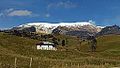 Nevado del Ruiz
 -
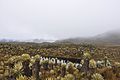 Nevado del Ruiz paramo
 -
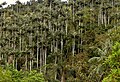 Wax palm
 -
 Buffy Helmetcrest (Oxypogon stuebelii)

_Murillo,_Tolima.jpg)

_(14343780309).jpg)

Footnotes
edit- ^ a b c Rangel-Ch., J. Orlando; Garzón-C., Aída (1997). "Region of Los Nevados Natural National Park". In Davis, S.D.; Heywood, V.H.; Herrera-MacBryde, O.; Villa-Lobos, J.; Hamilton, A. (eds.). Centres of Plant Diversity: A Guide and Strategy for Their Conservation. Volume 3: The Americas. Cambridge, England: World Wide Fund for Nature, International Union for Conservation of Nature and Natural Resources. ISBN 2-8317-0199-6. Archived from the original on 9 July 2010. Retrieved 11 July 2010..
- ^ a b c d e "Nature & Science Los Nevados". Parques Nacionales Naturales de Colombia. Archived from the original on 7 July 2011. Retrieved 11 July 2010.
- ^ IUCN 1982, p. 144
References
edit- IUCN (1982), IUCN directory of neotropical protected areas (in Spanish and English), IUCN, ISBN 978-0-907567-62-2.
- Villegas, Benjamin; Sesana, Laura (2007), Colombia Natural Parks, Villegas Asociados, ISBN 978-958-8156-87-3.
External links
edit![]() Media related to Parque Nacional Natural de los Nevados at Wikimedia Commons
Media related to Parque Nacional Natural de los Nevados at Wikimedia Commons