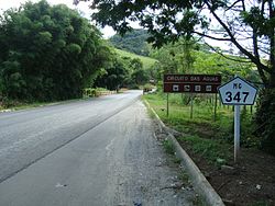
The MG-347 is a state highway located in the Brazilian state of Minas Gerais. Due to the direction it travels, it is considered a diagonal road.
| MG-347 | |
|---|---|
 Section of the MG-347 highway in the municipality of Cristina. | |
| Route information | |
| Length | 66 km (41 mi) |
| Major junctions | |
| Northeast end | Carmo de Minas |
| Southwest end | Junction with the BR-459 highway in Piranguinho |
| Location | |
| Country | Brazil |
| State | Minas Gerais |
| Highway system | |
Route
editThe MG-347 highway is 66 km (41 mi) long and is entirely paved.[1] It connects Carmo de Minas — a municipality in the Circuito das Águas[2] — to the BR-459 highway, in the municipality of Piranguinho.[3][4] The highway is located in the Mesoregion of the South and Southwest of Minas Gerais and passes through the municipalities of Carmo de Minas, Cristina, Pedralva, São José do Alegre and Piranguinho.[5]
References
edit- ^ "Rodovia MG-120" (PDF). DER-MG. p. 48. Archived from the original (PDF) on 2013-07-31. Retrieved 19 May 2021.
- ^ Secretaria de Estado de Turismo de Minas Gerais. "Circuito Turístico das Águas". Retrieved 8 February 2010.
- ^ Departamento de Estradas de Rodagem do Estado de Minas Gerais. "Mapa Rodoviário de Minas Gerais - quadro 23". Archived from the original (PDF) on 4 September 2009. Retrieved 8 February 2010.
- ^ Departamento Nacional de Infraestrutura de Transportes (2009). "Mapa Multimodal - Minas Gerais" (PDF). Archived from the original (PDF) on 2 February 2013. Retrieved 8 February 2010.
- ^ Instituto Brasileiro de Geografia e Estatística (2009). "Mapa Político do Estado de Minas Gerais" (PDF). Retrieved 8 February 2010.