This article needs additional citations for verification. (October 2024) |
Mažeikiai District Municipality (Lithuanian: Mažeikių rajono savivaldybė, Samogitian: Mažėikiu rajuona savivaldībė) is located in the north-west of Lithuania, on the River Venta in Telšiai County. The administrative center of Mažeikiai District is the city of Mažeikiai. Its territory of 1,220.2 km2 (471.1 sq mi) is composed of 32 km2 (12 sq mi) of towns and settlements, 22 km2 (8.5 sq mi) of industrial enterprises and roads, 614 km2 (237 sq mi) of agricultural lands, 273 km2 (105 sq mi) of forests, and 68 km2 (26 sq mi) of tracts of other designation. There is one urban and 8 rural elderates. In 2003, the population was 67,393. Of this number, 46,223 live in towns and 21,170 in villages.
Mažeikiai District Municipality
Mažeikių rajono savivaldybė | |
|---|---|
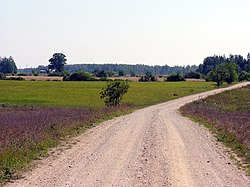
 Landscape near Marškonė | |
 Location of Mažeikiai district municipality within Lithuania | |
 Map of elderships of the Mažeikiai district municipality | |
| Country | |
| Ethnographic region | Samogitia |
| County | Telšiai County |
| Capital | Mažeikiai |
| Elderships | 9 |
| Area | |
| • Total | 1,220 km2 (470 sq mi) |
| • Rank | 30th |
| Population (2021[1]) | |
| • Total | 52,120 |
| • Rank | 10th |
| • Density | 43/km2 (110/sq mi) |
| • Rank | 12th |
| Time zone | UTC+2 (EET) |
| • Summer (DST) | UTC+3 (EEST) |
| Postal code | LT-89100 |
| Telephone code | 443 |
| Major settlements | |
| Website | www |
It is situated in northern Samogitia. Mažeikiai District borders with the Republic of Latvia in the north, with Akmenė District Municipality in the east, with Telšiai District Municipality in the southeast, with Plungė District Municipality in the southwest and with Skuodas District Municipality in the west. Mažeikiai District stretches for 43.5 km (27.0 mi) east-to-west and 38 km (24 mi) north-to-south. Petraičiai village is the westernmost settlement, with Kalniškiai and Pakliaupė villages being the easternmost settlements. The northernmost is Giniočiai, while the southernmost is Pasruojė.
Gallery
edit-
The River Venta in Mažeikiai district
-
Daubariai hillfort located in Mažeikiai District Municipality, Lithuania. Protected by the state.

