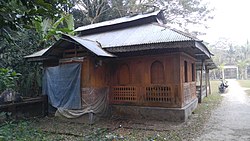
Mathbaria (Bengali: মঠবাড়িয়া) is an upazila consisting of eleven unions under Pirojpur district under Barisal division.The number of voters is about 2 lakh 9 thousand 706 and the number of new voters is 19 thousand 943[4]
Mathbaria
মঠবাড়িয়া | |
|---|---|
 Momin Mosque | |
 | |
| Coordinates: 22°17.2′N 89°58′E / 22.2867°N 89.967°E | |
| Country | |
| Division | Barisal |
| District | Pirojpur |
| Headquarters | Mathbaria |
| Area | |
• Total | 344.23 km2 (132.91 sq mi) |
| Population | |
• Total | 277,627 |
| • Density | 810/km2 (2,100/sq mi) |
| Time zone | UTC+6 (BST) |
| Postal code | 8560[2] |
| Area code | 04625[3] |
| Website | [1] |
Geography
editMathbaria is located at 22°17′13″N 89°58′00″E / 22.2869°N 89.9667°E. It has a total area of 344.23 km2.
History
editThe ancient history of Mathbaria dates back to the Mughal period. Subedar Murshid Quli Khan sent Aga Baker Khan to Kirtan Khola in the area of Chandradwip which was named Baker Ganj after him. It was named Mathbaria after the Hindu-dominated Math of Mathbaria in a lower area in the Mauza of Baker Ganj. Mathbaria police station was established in 1904. Mathbaria upazila currently has 1 municipality and 11 unions.The ancient history of Mathbaria has developed since the Mughal era. The Subedar Murshid Quli Khan sent Aga Baker Khan to name a location near the Kirtankhola River, which later became known as Bakerganj. In the Hindu-populated area here, it was named Mathbaria. The Mathbaria Thana was established in 1904. Currently, Mathbaria Upazila has 1 municipality and 11 unions.
Notable figures in Mathbaria's history include Mahyuddin Ahmed, Shaheed Noor Hossain, and Major (Retd) Mehedi Ali Imam. Significant water bodies in the area include the Baleshwari, Kocha, and Pona rivers.
The literacy rate is 62.8%, with a notable number of colleges, secondary schools, and primary schools. The primary source of income for the population is agriculture.
Local markets and fairs are significant. The electricity and drinking water supply systems in the upazila are improving, but the sanitation and health center conditions need enhancement.[5]
Demographics
editAccording to the 2011 Census of Bangladesh, Mathbaria Upazila had 61,187 households and a population of 262,841. 58,216 (22.15%) were under 10 years of age. Mathbaria has a literacy rate (age 7 and over) of 61.7%, compared to the national average of 51.8%, and a sex ratio of 1040 females per 1000 males. 48,024 (22.76%) lived in urban areas.[6][7]
Administration
editUNO: Abdul Kaium.[8]
Mathbaria Upazila is divided into Mathbaria Municipality and 11 union parishads: Amragasia, Betmor Rajpara, Boromasua, Daudkhali, Dhanishafa, Gulishakhali, Mathbaria, Mirukhali, Shapleza, Tikikata, and Tuskhali. The union parishads are subdivided into 67 mauzas and 93 villages.[9]
Mathbaria Municipality is subdivided into 9 wards and 16 mahallas.[9]
Notable people
edit- Hatem Ali Jamadar (1872–1982), member of the Bengal Legislative Assembly
- Shamim Shahnawaz membar of Perlament election 2024
See also
editReferences
edit- ^ a b Population and Housing Census 2022 - District Report: Pirojpur (PDF). District Series. Dhaka: Bangladesh Bureau of Statistics. June 2024. ISBN 978-984-475-260-3.
- ^ "Bangladesh Postal Code". Dhaka: Bangladesh Postal Department under the Department of Posts and Telecommunications of the Ministry of Posts, Telecommunications and Information Technology of the People's Republic of Bangladesh. 21 October 2024.
- ^ "Bangladesh Area Code". China: Chahaoba.com. 18 October 2024.
- ^ Md Mizanur Rahman (2012). "Mathbaria Upazila". In Sirajul Islam and Ahmed A. Jamal (ed.). Banglapedia: National Encyclopedia of Bangladesh (Second ed.). Asiatic Society of Bangladesh.
- ^ মঠবাড়িয়া উপজেলার ইতিহাস(The Ballpen)
- ^ "Community Report: Pirojpur" (PDF). Population & Housing Census 2011. Bangladesh Bureau of Statistics. Retrieved 15 August 2018.
- ^ "Bangladesh Population & Housing Census-2011, Zila Report: Pirojpur" (PDF). Bangladesh Bureau of Statistics. p. 18.
- ^ উপজেলা নির্বাহী অফিসার. 2024-08-26. Archived from the original on 2024-08-26.
- ^ a b "District Statistics 2011: Pirojpur" (PDF). Bangladesh Bureau of Statistics. Archived from the original (PDF) on 13 November 2014. Retrieved 14 July 2014.