This article needs to be updated. (December 2022) |
The Medford metropolitan area is a metropolitan area in the U.S. state of Oregon centered on the principal city of Medford, Oregon.[1] The U.S. Office of Management and Budget (OMB) identifies it as the Medford, OR Metropolitan Statistical Area, a metropolitan statistical area used by the United States Census Bureau (USCB) and other entities.[1] The OMB defines the area as comprising all of Jackson County, including Medford, Ashland and Central Point.[2] The Medford metropolitan area also includes Grants Pass in neighboring Josephine County, though the OMB excludes it.
Medford–Grants Pass | |
|---|---|
| Medford–Grants Pass, OR Combined Statistical Area | |
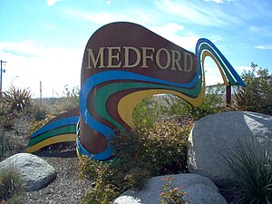
 Welcome sign near the north end of Medford | |
 | |
| Coordinates: 42°25′56″N 122°43′43″W / 42.4322°N 122.7286°W | |
| Country | |
| State | |
| Largest city | Medford |
| Other cities | Grants Pass Ashland Central Point Eagle Point |
| Highest elevation | 7,047 ft (2,148 m) |
| Lowest elevation | 430 ft (131 m) |
| Population | |
• Total | 285,919 |
| • Rank | 205th in the U.S. |
| • Density | 70/sq mi (26/km2) |
| Time zone | UTC−8 (PST) |
| • Summer (DST) | UTC−7 (PDT) |
Medford–Grants Pass, Oregon Combined Statistical Area
editThe USCB includes Medford and Grants Pass as a combined statistical area called the Medford–Grants Pass, Oregon Combined Statistical Area, comprising both Jackson and Josephine counties.[3][4] The area's population was estimated at 285,919 in 2010, making it the second largest combined statistical area and the fourth largest metropolitan area in Oregon, after Portland, Salem, and Eugene–Springfield.[5][6]
See also
editReferences
edit- ^ a b "OMB BULLETIN NO. 08 - 01" (archive). WhiteHouse.gov. U.S. Office of Management and Budget. 20 November 2007. p. 40. Retrieved 28 January 2018.
- ^ "MEDFORD, OR METRO AREA". Data USA. Retrieved 28 January 2018.
- ^ "OREGON - Core Based Statistical Areas (CBSAs) and Counties" (map). census.gov. U.S. Census Bureau. Retrieved 28 January 2018.
- ^ "MEDFORD - GRANTS PASS". CityPopulation.de. Retrieved 28 January 2018.
- ^ "US Census Bureau 2010 Census Interactive Population Map – Jackson County, OR". census.gov. U.S. Census Bureau. Retrieved 28 January 2018.
- ^ "US Census Bureau 2010 Census Interactive Population Map – Josephine County, OR". census.gov. U.S. Census Bureau. Retrieved 28 January 2018.
42°20′N 122°50′W / 42.333°N 122.833°W