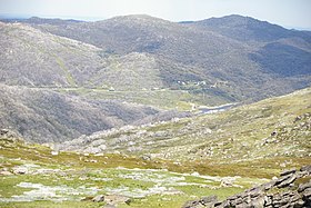
Mount Tate is a prominent rocky mountain on the Main Range of the Snowy Mountains located in southeastern New South Wales, Australia.
| Mount Tate | |
|---|---|
 The view southeast from Mount Tate | |
| Highest point | |
| Elevation | 2,068 m (6,785 ft)[1][2][3] |
| Prominence | 188 m (617 ft)[1] |
| Isolation | 5.59 km (3.47 mi)[1] |
| Coordinates | 36°21′S 148°21′E / 36.350°S 148.350°E[4] |
| Geography | |
Location in New South Wales | |
| Location | Snowy Mountains, New South Wales, Australia |
| Parent range | Main Range, Great Dividing Range |
| Climbing | |
| Easiest route | Walk (hike) |
With an elevation of 2,068 metres (6,785 ft) above sea level,[1] Mount Tate has two ridges running north and south, named Tate West Ridge and Tate East Ridge, referring to the side of the Great Divide where they lie. It has views along the Main Range towards Mount Twynam and down to the Geehi Valley.[5]
The mountain is situated approximately 3 kilometres (1.9 mi) northeast of Guthega and southwest of Guthega Power Station.[3]
See also
editReferences
edit- ^ a b c d "Mount Tate, Australia". Peakbagger.com. Retrieved 28 May 2015.
- ^ "Mount Tate - NSW". ExplorOz. I.T. Beyond Pty Ltd. 2015. Retrieved 27 May 2015.
- ^ a b "Map of Mount Tate, NSW". Bonzle Digital Atlas of Australia. Retrieved 27 May 2015.
- ^ "Mount Tate". Geographical Names Register (GNR) of NSW. Geographical Names Board of New South Wales. Retrieved 27 May 2015.
- ^ Geehi Bushwalking Club, (2001) 8th ed. Snowy Mountains Walks, Canberra: National Capital Printing. ISBN 0-9599651-4-9
