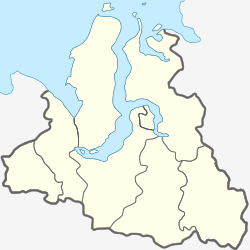
Novy Port (Russian: Но́вый Порт, lit. New Port) is a settlement in Yamalo-Nenets Autonomous Okrug, Russia, located on the mouth of the Ob River. Population: 1,797.[citation needed]
Novy Port
Новый Порт | |
|---|---|
| Coordinates: 67°41′31″N 72°53′47″E / 67.69194°N 72.89639°E | |
| Country | Russia |
| Federal subject | Yamalo-Nenets Autonomous Okrug |
| Founded | 1942 |
| Time zone | UTC+5 (MSK+2 |
| Postal code(s)[2] | |
| OKTMO ID | 71928414101 |

Along with Dikson, it is the main port on the Kara Sea.[4] Its main industry is a fish factory.
In the 1930s, Novy Port was an interim coal bunkering port for providing power to vessels traversing the Northern Sea Route.[5]
The Northern Sea Route is so long that the Soviets tried to power each leg of the voyage by locally mined coal. The coal bunkered at Novy Port was, at that time, mined from other Soviet Arctic ports.
Climate
editNovy Port has a severe subarctic climate (Köppen climate classification Dfc). The weather (even in the warmest month, July) is notoriously unpleasant. Winter lasts eight months, and precipitation is low throughout a year.
| Climate data for Novy Port | |||||||||||||
|---|---|---|---|---|---|---|---|---|---|---|---|---|---|
| Month | Jan | Feb | Mar | Apr | May | Jun | Jul | Aug | Sep | Oct | Nov | Dec | Year |
| Record high °C (°F) | 0.6 (33.1) |
1.4 (34.5) |
7.1 (44.8) |
6.1 (43.0) |
17.6 (63.7) |
29.7 (85.5) |
32.8 (91.0) |
30.1 (86.2) |
22.5 (72.5) |
13.7 (56.7) |
3.6 (38.5) |
0.7 (33.3) |
32.8 (91.0) |
| Mean daily maximum °C (°F) | −21.1 (−6.0) |
−20.6 (−5.1) |
−15.6 (3.9) |
−9.4 (15.1) |
−1.7 (28.9) |
10.6 (51.1) |
17.2 (63.0) |
14.1 (57.4) |
8.2 (46.8) |
−3.9 (25.0) |
−12.8 (9.0) |
−17.2 (1.0) |
−4.4 (24.2) |
| Daily mean °C (°F) | −23.9 (−11.0) |
−23.9 (−11.0) |
−18.3 (−0.9) |
−12.8 (9.0) |
−4.4 (24.1) |
6.2 (43.2) |
13.0 (55.4) |
10.6 (51.1) |
5.3 (41.5) |
−6.1 (21.0) |
−15.6 (3.9) |
−19.4 (−2.9) |
−7.4 (18.6) |
| Mean daily minimum °C (°F) | −27.8 (−18.0) |
−27.8 (−18.0) |
−22.8 (−9.0) |
−17.2 (1.0) |
−6.7 (19.9) |
2.8 (37.0) |
8.7 (47.7) |
6.9 (44.4) |
2.4 (36.3) |
−8.3 (17.1) |
−18.3 (−0.9) |
−23.9 (−11.0) |
−11.0 (12.2) |
| Record low °C (°F) | −50.9 (−59.6) |
−49.4 (−56.9) |
−48.1 (−54.6) |
−39.9 (−39.8) |
−29.2 (−20.6) |
−13.3 (8.1) |
−0.9 (30.4) |
−4 (25) |
−14.7 (5.5) |
−30.3 (−22.5) |
−40.3 (−40.5) |
−47.7 (−53.9) |
−50.9 (−59.6) |
| Average precipitation mm (inches) | 24.8 (0.98) |
19.1 (0.75) |
22.2 (0.87) |
23.0 (0.91) |
26.3 (1.04) |
31.7 (1.25) |
35.6 (1.40) |
47.7 (1.88) |
37.5 (1.48) |
36.7 (1.44) |
25.6 (1.01) |
27.2 (1.07) |
357.4 (14.07) |
| Source: climatebase.ru[6] | |||||||||||||
References
edit- ^ "Об исчислении времени". Официальный интернет-портал правовой информации (in Russian). 3 June 2011. Retrieved 19 January 2019.
- ^ Почта России. Информационно-вычислительный центр ОАСУ РПО. (Russian Post). Поиск объектов почтовой связи (Postal Objects Search) (in Russian)
- ^ Russian Federal State Statistics Service (2011). Всероссийская перепись населения 2010 года. Том 1 [2010 All-Russian Population Census, vol. 1]. Всероссийская перепись населения 2010 года [2010 All-Russia Population Census] (in Russian). Federal State Statistics Service.
- ^ Andrew Revkin (2009-09-04). "Commercial Arctic Passage Nearing Goal". New York Times. Retrieved 2009-09-05.
- ^ Constantine Krypton (1956). The northern sea route and the economy of the Soviet North. Taylor & Francis. ISBN 978-0-8371-8886-7. Archived from the original on 2012-10-26.
- ^ "23242: Novy Port (Russia)". ogimet.com. OGIMET. 8 August 2022. Retrieved 9 August 2022.


