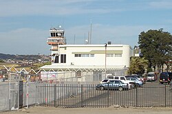
Pavas is the ninth district of the San José canton, in the San José province of Costa Rica.[1][2] The district comprises Tobías Bolaños International Airport, San José's domestic airport.
Pavas | |
|---|---|
 Control tower and main terminal building, Tobias Bolaños International Airport, Pavas, San José, Costa Rica | |
 Pavas district | |
| Coordinates: 9°56′58″N 84°08′21″W / 9.9495224°N 84.1391744°W | |
| Country | |
| Province | San José |
| Canton | San José |
| Area | |
| • Total | 9.39 km2 (3.63 sq mi) |
| Elevation | 1,044 m (3,425 ft) |
| Population (2011) | |
| • Total | 71,384 |
| • Density | 7,600/km2 (20,000/sq mi) |
| Time zone | UTC−06:00 |
| Postal code | 10109 |
Geography
editPavas has an area of 9.39 km2 (the largest district in the canton) [3] and an elevation of 1,044 metres.[1]
It is adjacent to Escazú Canton to the south, and to Uruca and Mata Redonda districts to the north and east respectively.[4]
Demographics
edit| Census | Pop. | ±% p.a. |
|---|---|---|
| 1883 | 732 | — |
| 1892 | 954 | +2.99% |
| 1927 | 1,499 | +1.30% |
| 1950 | 2,127 | +1.53% |
| 1963 | 5,530 | +7.63% |
| 1973 | 18,068 | +12.57% |
| 1984 | 31,690 | +5.24% |
| 2000 | 76,177 | +5.63% |
| 2011 | 71,384 | −0.59% |
| 2022 | 83,573 | +1.44% |
| Source: Instituto Nacional de Estadística y Censos[5] Centro Centroamericano de Población[6] | ||
For the 2011 census, Pavas had a population of 71,384 inhabitants.[7]
Locations
editPavas District includes the "barrios" (or neighbourhoods) of Aeropuerto, Alfa, Bribri, Favorita Norte, Favorita Sur, Geroma, Gerona, Hispana, Libertad, Lomas del Río, Llanos del Sol, María Reina, Metrópolis, Pavas Centro, Residencia del Oeste, Rincón Grande, Rohrmoser, Rotonda, San Pedro, Santa Bárbara, Santa Catalina, Tajo, Triángulo, Villa Esperanza, and Zona Industrial.
Education
editThis section needs expansion. You can help by adding to it. (March 2015) |
International schools include:
- British School of Costa Rica[8]
- Colegio Humboldt (Humboldt-Schule) - German school[9]
Transportation
editRoad transportation
editThe district is covered by the following road routes:
Rail transportation
editThe Interurbano Line operated by Incofer goes through this district.
References
edit- ^ a b "Declara oficial para efectos administrativos, la aprobación de la División Territorial Administrativa de la República N°41548-MGP". Sistema Costarricense de Información Jurídica (in Spanish). 19 March 2019. Retrieved 26 September 2020.
- ^ División Territorial Administrativa de la República de Costa Rica (PDF) (in Spanish). Editorial Digital de la Imprenta Nacional. 8 March 2017. ISBN 978-9977-58-477-5.
- ^ "Área en kilómetros cuadrados, según provincia, cantón y distrito administrativo". Instituto Nacional de Estadística y Censos (in Spanish). Retrieved 26 September 2020.
- ^ Mapa Cantonal del Censo de 1984, published by the National Institute of Statistics and Census(INEC) and updated by the Central American Population Center (CCP)
- ^ "Instituto Nacional de Estadística y Censos" (in Spanish).
- ^ Centro Centroamericano de Población de la Universidad de Costa Rica. "Sistema de Consulta a Bases de Datos Estadísticas" (in Spanish).
- ^ "Censo. 2011. Población total por zona y sexo, según provincia, cantón y distrito". Instituto Nacional de Estadística y Censos (in Spanish). Retrieved 26 September 2020.
- ^ "Contact." British School of Costa Rica. Retrieved on March 15, 2015. "Our Address From the end of the Rohrmoser Boulevard 125 m. North, Urbanización Santa Catalina Pavas, San José, Costa Rica"
- ^ "Contáctenos." Colegio Humboldt. Retrieved on 15 March 2015. "Dirección: Contiguo a la Iglesia Nuestra Señora de Loreto, Pavas, San José"
