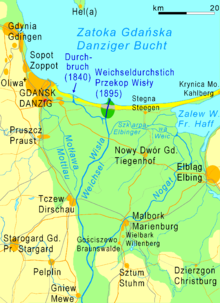
The Przekop Wisły (Polish pronunciation: [ˈpʂɛkɔp], often shortened to just Przekop) is a branch of the Vistula river in its delta. It was created artificially in 1895 (hence its Polish name "Przekop" in this case meaning "river cutoff"). Since then, it has formed the most direct route from the Vistula to the Baltic Sea.
| Przekop Wisły | |
|---|---|
 A view of the Przekop towards its mouth | |
 | |
| Location | Between Sobieszewo Island and Gmina Stegna, Pomeranian Voivodeship |
| Country | Poland |
| Specifications | |
| Length | 7.1 km (4.4 miles) |
| History | |
| Former names | Weichseldurchstich |
| Modern name | Przekop Wisły |
| Construction began | June 1891 |
| Date completed | March 1895 |
| Geography | |
| Start point | Mikoszewo or Świbno |
| End point | Gdańsk Bay |
| Beginning coordinates | 54°18′31″N 18°56′03″E / 54.3085°N 18.9342°E |
| Ending coordinates | 54°21′38″N 18°57′00″E / 54.3606°N 18.9501°E |
 | |
History
editWork on the Przekop began in June 1891. 1,000 workers and 40 steam machines were dedicated to the project. 7,000,000 cubic metres (250,000,000 cu ft) of dirt was displaced from the construction site. 20 million marks were spent on the project in total.[1] An opening ceremony was not held once the canal was finished—at 3:45 p.m. on 31 March 1895, president of East Prussia Gustav von Goßler was sent a telegraph signal by Wilhelm II, German Emperor, to open the canal. He followed the Emperor's orders and opened it by himself.[2][3]
Measurements
editThe Przekop is 7.1 kilometres (4.4 mi) long[4] and 250 to 400 metres (820 to 1,310 ft) wide,[5] with shallows measuring 1 metre (3.3 ft) in depth. In June 2022, the water levels of the Przekop reached 526 centimetres (207 in).[6]
Geology
editThe deposition of the sediments on the canal's surface is progressing at a fast pace and its surface is mostly made up of coarse sands with leptokurtic distribution.[7]
References
edit- ^ Kuhn, Rudolf (2012). Rudolf Th. Kuhn (1842–1900)—fotograf krajobrazu, architektury i morza. Fundacja Karrenwall. ISBN 9788393309412.
- ^ Chudzyński, Tomasz (28 February 2021). "Historia przekopu Wisły! Duma i nowoczesność Zachodnich Prus do dziś chroni Żuławy przed powodzią. Znacie tę historię?". Nowy Dwór Gdański Naszemiasto. Naszemiasto. Retrieved 13 February 2023.
- ^ "Tak przekopano Wisłę ponad 120 lat temu". Strefa Historii. Północ TV. 20 December 2016. Retrieved 13 February 2023.
- ^ "Przekop Wisły". Młyńska Droga. 23 October 2020. Retrieved 13 February 2023.
- ^ "Przekop Wisły wraz z jej ujściem". Pomorskie.travel. Retrieved 13 February 2023.
- ^ Palacz, Marcin (6 June 2022). "Ujście Wisły". Jacht i Bałtyk. Retrieved 13 February 2022.
- ^ Rudowski, S.; Wróblewski, R.; Edut, J.; Dworniczak, J. (2017). "Granulometry of bottom sediments of the Przekop Wisły canal". Bulletin of the Maritime Institute of Gdańsk. 32 (1). doi:10.5604/12307424.1224050. Retrieved 13 February 2023.
54°19′40″N 18°56′15″E / 54.32778°N 18.93750°E
