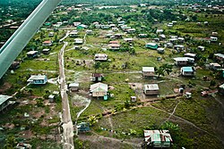
Puerto Cabezas, also known as Bragman's Bluff (Spanish pronunciation: [ˈpweɾ.to ka.ˈβe.sas]; Miskito: Bilwi) is a municipality and city in Nicaragua. It is the capital of Miskito nation in the North Caribbean Coast Autonomous Region.
Puerto Cabezas | |
|---|---|
Municipality | |
 Aerial view of city | |
| Coordinates: 14°01′41″N 83°22′51″W / 14.02806°N 83.38083°W | |
| Country | |
| Department | |
| Area | |
• Municipality | 2,310.75 sq mi (5,984.81 km2) |
| Population (2023 estimate)[1] | |
• Municipality | 138,353 |
| • Density | 60/sq mi (23/km2) |
| • Urban | 86,279 |
| Time zone | UTC-6 (Central Time) |
| • Summer (DST) | UTC-6 (No DST) |
| Climate | Am |
The municipality and the entire region are native American lands. The city of Puerto Cabezas borders the Community of Ten Communities.
History
editHurricane Felix hit Puerto Cabezas on September 4, 2007, killing about 100 people.[2] Hurricane Eta hit the city on November 3, 2020, causing extensive damage.[3] On November 16, 2020, Hurricane Iota hit the city as a strong Category 4.
Climate
editPuerto Cabezas has a tropical monsoon climate (Köppen climate classification Am) with significant rainfall year round, and a short dry season in March and April. Even so, these months see an average rainfall of 48 millimetres (1.9 in) and 54 millimetres (2.1 in).[4] The average temperature ranges from 24.5 °C (76.1 °F) in February to 27.8 °C (82.0 °F) in May.[4] The average annual rainfall is 2,799 millimetres (110 in), while 198 days receive measurable rain during an average year.[4]
| Climate data for Puerto Cabezas | |||||||||||||
|---|---|---|---|---|---|---|---|---|---|---|---|---|---|
| Month | Jan | Feb | Mar | Apr | May | Jun | Jul | Aug | Sep | Oct | Nov | Dec | Year |
| Mean daily maximum °C (°F) | 29.7 (85.5) |
29.7 (85.5) |
30.5 (86.9) |
31.3 (88.3) |
31.8 (89.2) |
31.4 (88.5) |
30.8 (87.4) |
31.2 (88.2) |
31.2 (88.2) |
31.6 (88.9) |
30.8 (87.4) |
29.7 (85.5) |
30.8 (87.5) |
| Daily mean °C (°F) | 25.0 (77.0) |
24.5 (76.1) |
26.5 (79.7) |
27.2 (81.0) |
27.8 (82.0) |
27.5 (81.5) |
27.1 (80.8) |
27.1 (80.8) |
27.0 (80.6) |
26.3 (79.3) |
25.8 (78.4) |
25.4 (77.7) |
26.4 (79.6) |
| Mean daily minimum °C (°F) | 18.8 (65.8) |
18.6 (65.5) |
19.8 (67.6) |
20.9 (69.6) |
21.8 (71.2) |
22.0 (71.6) |
21.9 (71.4) |
22.0 (71.6) |
22.2 (72.0) |
21.6 (70.9) |
20.8 (69.4) |
19.3 (66.7) |
20.8 (69.4) |
| Average rainfall mm (inches) | 148 (5.8) |
83 (3.3) |
48 (1.9) |
54 (2.1) |
183 (7.2) |
378 (14.9) |
414 (16.3) |
370 (14.6) |
303 (11.9) |
338 (13.3) |
278 (10.9) |
202 (8.0) |
2,799 (110.2) |
| Average rainy days (≥ 1.0 mm) | 16 | 11 | 7 | 8 | 12 | 20 | 23 | 22 | 20 | 20 | 19 | 20 | 198 |
| Source: Hong Kong Observatory[4] | |||||||||||||
Culture
editPuerto Cabezas culture is diverse, being Miskito culture the dominant, followed by Creole, Mayangna and Latino.
The culture, like the rest of Nicaragua's Caribbean coast, has a very prominent Caribbean influence.
Education
editThe University of the Autonomous Regions of the Nicaraguan Caribbean Coast (URACCAN) has a campus in Puerto Cabezas, as well as in several other locations in the RACCN and the RACCS.
Transportation
editThe city is served by Puerto Cabezas Airport.
Twin towns – sister cities
editPuerto Cabezas is sister city to:
- Burlington, United States[5]
- Luleå, Sweden[6]
- Sant Pere de Ribes, Spain[7]
- Vilafranca del Penedès, Spain[8]
See also
editReferences
edit- ^ Anuario Estadístico 2022. Instituto Nacional de Información de Desarrollo (INIDE)
- ^ AFP news Archived 2007-12-09 at the Wayback Machine
- ^ Reuters (November 3, 2020). "Hurricane Eta pounds Nicaragua as Category 4 storm". cnbc.com. CNBC. Retrieved November 3, 2020.
{{cite web}}:|author=has generic name (help) - ^ a b c d "Climatological Information for Puerto Cabezas, Nicaragua". Hong Kong Observatory. Archived from the original on September 26, 2013. Retrieved December 6, 2012.
- ^ "Sister Cities". burlingtonvt.gov. City of Burlington. Retrieved 2021-10-03.
- ^ "Vänorter". lulea.se (in Swedish). Luleå kommun. Retrieved 2021-10-03.
- ^ "Agermanament amb Puerto Cabezas". santperederibes.cat (in Catalan). Sant Pere de Ribes. Retrieved 2021-10-03.
- ^ "Relacions bilaterals". vilafranca.cat (in Catalan). Vilafranca del Penedès. Retrieved 2021-10-03.


