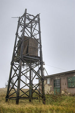
RAF Oxenhope Moor was a British Second World War radio station, located on Cock Hill Moor near the village of Oxenhope in Yorkshire.[1] It was known by a number of different names, including Oxenhope Laboratory, Oxenhope Radar Station and Oxenhope Weather Station.
| RAF Oxenhope Moor | |
|---|---|
| Yorkshire, England | |
 The remains of a communications mast at RAF Oxenhope. | |
| Coordinates | 53°47′29″N 1°59′02″W / 53.7913°N 1.984°W |
| Site information | |
| Controlled by | Royal Air Force |
| Condition | demolished |
| Site history | |
| In use | 1942–1970 |
The station was built during the Second World War and was used as part of the GEE navigation system (started in March 1942) used to guide bombers to their targets in Europe. The station was maintained by the RAF as No. 585 Signals Unit until 1970,[2] and was then taken over by the University of Bradford.[3]
Notes and references
edit- ^ Wood, Steven; Palmer, Ian (2009). Oxenhope & Stanbury through time. Stroud: Amberley. p. 49. ISBN 978-1848685239.
- ^ "Gee Chain Closure". Flight International. 97 (3185). Reed Business Information Ltd: 536. 26 March 1970. Retrieved 1 January 2010.
- ^ "Former RAF radar station to be bulldozed". Hebden Bridge Times. 16 October 2008. Retrieved 1 January 2010.
