Rapid City, South Dakota metropolitan area
The Rapid City, SD metropolitan area, as defined by the United States Census Bureau. Anchored by the city of Rapid City, the area corresponds to the entirety of Pennington and Meade counties in the state of South Dakota, though the Rapid City market area extends well beyond those counties and into Nebraska, Montana, Wyoming, and North Dakota. The population was 139,074 at the 2020 census. According to 2022 census estimates, the MSA is estimated to have a population of 145,159.[1]
Rapid City, SD Metropolitan Statistical Area | |
|---|---|
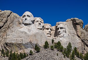
 Mount Rushmore near Keystone | |
 | |
| Coordinates: 44°04′17″N 103°13′15″W / 44.07139°N 103.22083°W | |
| Country | |
| State | |
| Largest city | Rapid City |
| Other cities | Spearfish Sturgis Deadwood |
| Area | |
• Total | 41,910 km2 (16,181 sq mi) |
| Population (2020) | |
• Total | 139,074 |
• Estimate (2022)[1] | 145,159 |
| • Rank | US: 279th |
| • Density | 8.971/km2 (23.23/sq mi) |
| Time zone | UTC−7 (MST) |
| • Summer (DST) | UTC−6 (CDT) |
| Area code | 605 |
Counties
editCommunities
editPlaces with more than 75,000 inhabitants
edit- Rapid City (Principal city)
Places with 2,000 to 20,000 inhabitants
edit- Blackhawk (census-designated place)
- Box Elder
- Ellsworth AFB (former census-designated place)
- Piedmont
- Rapid Valley (census-designated place)
- Sturgis
- Summerset
Places with 750 to 2,000 inhabitants
edit- Colonial Pine Hills (census-designated place)
- Green Valley (census-designated place)
- Hill City
Places with less than 750 inhabitants
edit- Ashland Heights (census-designated place)
- Blucksberg Mountain
- Buffalo Chip
- Caputa
- Faith
- Johnson Siding
- Keystone
- New Underwood
- Quinn
- Wall
- Wasta
Unincorporated places
editDemographics
edit| Census | Pop. | Note | %± |
|---|---|---|---|
| 1880 | 2,244 | — | |
| 1890 | 11,180 | 398.2% | |
| 1900 | 10,517 | −5.9% | |
| 1910 | 25,093 | 138.6% | |
| 1920 | 22,087 | −12.0% | |
| 1930 | 31,561 | 42.9% | |
| 1940 | 33,534 | 6.3% | |
| 1950 | 45,569 | 35.9% | |
| 1960 | 70,239 | 54.1% | |
| 1970 | 75,967 | 8.2% | |
| 1980 | 91,078 | 19.9% | |
| 1990 | 103,221 | 13.3% | |
| 2000 | 112,818 | 9.3% | |
| 2010 | 126,382 | 12.0% | |
| 2020 | 139,074 | 10.0% | |
| 2022 (est.) | 145,159 | [1] | 4.4% |
| U.S. Decennial Census[2] 2020 Census | |||
2020 census
editAs of the 2020 census, there were 139,074 people and 58,790 households in the MSA.
2010 census
editThe ethnic makeup of the MSA, according to the 2010 census, was the following:
- 85.26% White
- 8.19% Native American
- 1.08% Black
- 0.96% Asian
- >0.01% Native Hawaiian or Pacific Islander
- 3.63% Two or more races
- 0.80% Other races
- 3.63% Hispanic or Latino (of any race)
As of the 2010 census, there were 126,382 people, 51,154 households, and 33,390 families residing in the MSA. The population density was 20.2 people per square mile (7.8/km2). There were 55,949 housing units at an average density of 8.9 per square mile (3.4/km2). 27.9% were of German, 7.2% Irish, 6.7% Norwegian, and 5.2% English ancestry.
There were 51,154 households, out of which 32.0% had children under the age of 18 living with them, 49.2% were married couples living together, 11.2% had a female householder with no husband present, and 34.7% were non-families. 28.0% of all households were made up of individuals, and 9.4% had someone living alone who was 65 years of age or older. The average household size was 2.45 and the average family size was 2.93.
2000 census
editAs of the 2000 census, there were 112,818 people, 43,446 households, and 29,978 families residing within the MSA. The racial makeup of the MSA was 87.98% White, 0.99% African American, 6.79% Native American, 0.82% Asian, 0.06% Pacific Islander, 0.67% from other races, and 2.69% from two or more races. Hispanic or Latino of any race were 2.53% of the population.
The median income for a household in the MSA was $37,239, and the median income for a family was $42,667. Males had a median income of $28,590 versus $21,029 for females. The per capita income for the MSA was $18,309.
See also
editReferences
edit- ^ a b c "Metropolitan and Micropolitan Statistical Areas Population Totals and Components of Change: 2020-2022". United States Census Bureau. United States Census Bureau. Retrieved December 11, 2023.
- ^ United States Census Bureau. "Census of Population and Housing". Retrieved September 23, 2013.