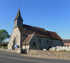
Lavant is a civil parish in the Chichester district of West Sussex, England, 2.2 miles (3.5 km) north of Chichester. It includes three villages: Mid Lavant[3] and East Lavant,[4] which are separate Anglican parishes, and the much smaller West Lavant. It takes its name from the River Lavant which flows from East Dean to Chichester.
| Lavant | |
|---|---|
 Church of St Nicholas, Mid Lavant | |
Location within West Sussex | |
| Area | 16.53 km2 (6.38 sq mi) [1] |
| Population | 1,656. 2011[2] |
| • Density | 96/km2 (250/sq mi) |
| OS grid reference | SU857087 |
| • London | 52 miles (84 km) NNE |
| Civil parish |
|
| District | |
| Shire county | |
| Region | |
| Country | England |
| Sovereign state | United Kingdom |
| Post town | CHICHESTER |
| Postcode district | PO18 |
| Police | Sussex |
| Fire | West Sussex |
| Ambulance | South East Coast |
| UK Parliament | |
| Website | [1] |
The A286 road between Chichester and Midhurst runs through the parish.
The villages were served by a station in Mid Lavant, on the railway line that ran between Chichester and Midhurst, but this closed in stages between 1931 and 1991.
History
editPrehistory
editIn 1993, the Lavant drum, a small Neolithic cylinder, was discovered during excavations at Chalk Pit Lane. It is one of only five known objects of its type, and the only one discovered outside of Yorkshire. (The other four are the three Folkton drums, discovered in 1889 in North Yorkshire,[5] and the Burton Agnes drum, discovered in 2015 in East Yorkshire.[6]) It has been suggested that these objects were tools used to measure cord to standard lengths which were used in the construction of monuments such as Stonehenge and the timber circle at Durrington Walls.[7]
East Lavant
editEast Lavant was listed in the Domesday Book.[8]
In 1861, the population of the parish (with West Lavant) was 421, and the area was 2,884 acres (1,167 ha).[4]
Mid Lavant
editMid Lavant (Loventone) was listed in the Domesday Book (1086) in the ancient hundred of Singleton as having 20 households: 10 villagers and 10 smallholders; with ploughing land and a mill, it had a value to the lords of the manor, Guy of Lavant and Ivo of Grandmesnil, of £9.[9]
In 1861, the area of the small parish was 350 acres (140 ha), and described in Kelly's Directory of 1867 as "principally arable". The population in 1861 was 257. The Duke of Richmond was the principal landowner and patron of the parish church.[10] The village pub is named after the Earl of March.
The parish church is dedicated to St Nicholas.[3] It contains the vault of the May family, seated at Rawmere House in Mid Lavant, with a monument of Lady Mary May by John Bushnell.
Landmarks
editKingley Vale lies on the border of the parish; it is a Site of Special Scientific Interest, a national nature reserve and is noted for its yew woodlands.[11] Archaeological remains from the Bronze Age, Iron Age and Roman times have been identified.[12][13]
Governance
editAn electoral ward in the same name exists. This ward includes Westhampnett with a total ward population taken at the 2011 census of 2,365.[14]
Sport
editLavant is home to two sporting clubs, Lavant Football Club[15] and Lavant Cricket Club.[16]
Notable people
edit- William Humphry (1814–1865), cricketer[17]
References
edit- ^ "2001 Census: West Sussex – Population by Parish" (PDF). West Sussex County Council. Archived from the original (PDF) on 8 June 2011. Retrieved 5 May 2009.
- ^ "Civil Parish population 2011". Archived from the original on 5 March 2016. Retrieved 15 October 2015.
- ^ a b "GENUKI: Mid Lavant". Retrieved 24 June 2019.
- ^ a b "GENUKI: East Lavant". Retrieved 24 June 2019.
- ^ Kenny, James; Teather, Anne M. (2016). "New insights into the Neolithic chalk drums from Folkton (North Yorkshire) and Lavant (West Sussex)". PAST: The Newsletter of the Prehistoric Society. 83: 5–6.
- ^ "British Museum's Stonehenge exhibition adds 'most important prehistoric art find in 100 years'". Museums + Heritage Advisor. 10 February 2022. Archived from the original on 11 February 2022.
- ^ Teather, Anne; Chamberlain, Andrew; Parker Pearson, Mike (2 January 2019). "The chalk drums from Folkton and Lavant: Measuring devices from the time of Stonehenge". British Journal for the History of Mathematics. 34 (1): 1–11. doi:10.1080/17498430.2018.1555927. ISSN 2637-5451.
- ^ "Open Domesday: East Lavant". Retrieved 24 June 2019.
- ^ "Open Domesday: Mid Lavant". Retrieved 24 June 2019.
- ^ "Laughton – Laverstoke Pages 33-37 A Topographical Dictionary of England. Originally published by S Lewis, London, 1848". British History Online.
- ^ "SSSI Citation – Kingley Vale" (PDF). Natural England. Archived from the original (PDF) on 25 May 2011. Retrieved 4 April 2009.
- ^ Down, Alec (1979). "Gazeteer of Sites and Finds". Chichester Excavations. 4. Chichester: Phillimore & Co. Ltd.: 36–7. ISBN 0-85033-344-X.
- ^ Boyden, J. R. (1956). "Excavations at Goosehill Camp, 1953-5". Sussex Archaeological Collections. 94: 70–99. doi:10.5284/1085886.
- ^ "Ward population 2011". Archived from the original on 4 February 2016. Retrieved 15 October 2015.
- ^ "Lavant Football Club". Club Website. Retrieved 10 June 2018.
- ^ "Lavant Cricket Club". Archived from the original on 9 June 2018. Retrieved 2 May 2017.
- ^ "Player profile: William Humphry". CricketArchive. Archived from the original on 19 October 2013. Retrieved 30 June 2012.
