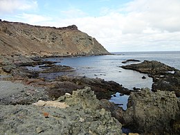
Selvagem Grande Island is part of the Savage Islands archipelago, which themselves are part of the Portuguese Autonomous Region of Madeira in the North Atlantic Ocean.
 View of Selvagem Grande | |
 | |
| Geography | |
|---|---|
| Location | Atlantic Ocean |
| Coordinates | 30°08′51″N 15°51′54″W / 30.14750°N 15.86500°W |
| Archipelago | Savage Islands |
| Highest elevation | 163 m (535 ft) |
| Highest point | Pico da Atalaia |
| Administration | |
Portugal | |
| Autonomous Region | Madeira Islands |
| Demographics | |
| Population | no permanent residents (2+ rangers and research personnel) |
The island (2,000 by 1,700 metres (6,600 ft × 5,600 ft)) belongs to the northeast group of the Savage Islands, which comprises in addition three islets: Sinho Islet, Palheiro de Terra and Palheiro do Mar.[1]
It is generally flat, but has three summits, remnants of former volcanic cones appropriately named Atalaia, Tornozelos and Inferno, Atalaia being the highest of the three, reaching 163 m (535 ft) in altitude.[1]
The island has three residents year-round, two park rangers and a biologist.[1]
The island has a lighthouse, which is automated.[2]
-
Nautical chart of the archipelago (1884)
-
The Selvagem Grande Island
-
Sentinel-2 image of the island (October 2021)
-
Northern Island, aerial view
-
Side view of the Island
-
Warden's base
References
edit- ^ a b c "Marine Biodiversity and Ecosystem Health of Ilhas Selvagens, Portugal" (PDF). National Geographic Society. Retrieved 4 November 2020.
- ^ Lighthouse Depot Online - Selvagem Grande Light Archived 2007-03-10 at the Wayback Machine


