This article needs additional citations for verification. (February 2024) |
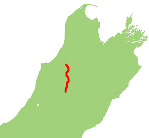
State Highway 65 (also known as the Shenandoah Highway) is a New Zealand state highway in the South Island. It is 71 km long and runs south to north down the Maruia river valley from SH 7 at Springs Junction, 15 km west of the main divide at the Lewis Pass, to SH 6 in the Buller Gorge, 11 km west of Murchison. It forms part of the most direct route between Christchurch and Nelson. It takes its name from a small settlement toward its northern end.
| State Highway 65 | ||||
|---|---|---|---|---|
 | ||||
| Route information | ||||
| Maintained by NZ Transport Agency | ||||
| Length | 71.7 km (44.6 mi) | |||
| Major junctions | ||||
| North end | ||||
| South end | ||||
| Location | ||||
| Country | New Zealand | |||
| Primary destinations | Shenandoah, Maruia | |||
| Highway system | ||||
| ||||
The road is sealed and two-lane, with some single-lane bridges. The surrounding country is used for pastoral farming (beef and dairy) with some forestry on the surrounding hills. Springs Junction is the only locality with fuel or food along the route while Maruia is the largest settlement along the route.

Maruia Falls, a 5-m waterfall near the road, did not exist prior to the 1929 Murchison earthquake (magnitude 7.8).
In 2019 a part of the road between Murchison and Maruia faced erosion from the Maruia River, caused by heavy rain.[1]
See also
editReferences
edit- ^ Sivignon, Cherie. "Eroded section of Nelson-Christchurch highway down to one lane for months". stuff.co.nz. Archived from the original on 6 June 2020.
External links
edit
