Ixopo, also known as Stuartstown, is a town situated on a tributary of the uMkhomazi River along the R56 highway in the midlands of KwaZulu-Natal, South Africa.
Ixopo
Stuartstown | |
|---|---|
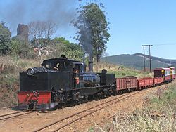
 SAR Class NG G11 no. NG55 arriving at Ixopo station | |
| Coordinates: 30°09′26″S 30°03′53″E / 30.15722°S 30.06472°E | |
| Country | South Africa |
| Province | KwaZulu-Natal |
| District | Harry Gwala |
| Municipality | Ubuhlebezwe |
| Area | |
• Total | 10.85 km2 (4.19 sq mi) |
| Population (2011)[1] | |
• Total | 12,461 |
| • Density | 1,100/km2 (3,000/sq mi) |
| Racial makeup (2011) | |
| • Black African | 90.6% |
| • Coloured | 5.6% |
| • Indian/Asian | 1.9% |
| • White | 1.4% |
| • Other | 0.5% |
| First languages (2011) | |
| • Zulu | 74.8% |
| • English | 10.6% |
| • Xhosa | 7.6% |
| • Sotho | 2.2% |
| • Other | 4.8% |
| Time zone | UTC+2 (SAST) |
| Postal code (street) | 3276 |
| PO box | 3276 |
| Area code | 039 |
Background
editThe town was laid out in 1878 and named after M Stuart, Resident Magistrate of the surrounding district, who was killed at the Battle of Ingogo in 1881.[2][3]: 256 Its name is derived from the Zulu onomatopoeic word, eXobo, describing the sound made as cattle squelch through mud.[3]: 256 The 'x', in Zulu, is pronounced as a lateral click.
The town is most famously described by Alan Paton in the opening lines of Cry, The Beloved Country: "There is a lovely road which runs from Ixopo into the hills. These hills are grass covered and rolling, and they are lovely beyond any singing of it."[3]: 256
Until the mid-1980s, Ixopo was served by a railway station on the 610 mm (2 ft 0 in) narrow gauge Umzinto - Donnybrook narrow gauge railway.[3]: 256
Notable people
edit- Thabo Nodada (Footballer)
- Purity Nomthandazo Malinga (Bishop)
- Ray Zondo (Chief Justice, Constitutional Court of South Africa)
References
edit- ^ a b c d "Main Place Ixopo". Census 2011.
- ^ "Dictionary of Southern African Place Names (Public Domain)". Human Science Research Council. p. 421.
- ^ a b c d Conolly, Denis (1975). The Tourist in South Africa. Travel-Guide (PTY) LTD. ASIN B0000E7XZN.
3. R56 information Route 56 - Ixopo

